IMAGES TAKEN NEAR TO
Fawnbrake Avenue, LONDON, SE24 0BY
Introduction
This page details the photographs taken nearby to Fawnbrake Avenue, SE24 0BY by members of the Geograph project.
The Geograph project started in 2005 with the aim of publishing, organising and preserving representative images for every square kilometre of Great Britain, Ireland and the Isle of Man.

There are currently over 7.5m images from over14,400 individuals and you can help contribute to the project by visiting https://www.geograph.org.uk
Image Map
Images are licensed for reuse under creativecommons.org/licenses/by-sa/2.0
Notes
- Clicking on the map will re-center to the selected point.
- The higher the marker number, the further away the image location is from the centre of the postcode.
Image Listing (82 Images Found)
Images are licensed for reuse under creativecommons.org/licenses/by-sa/2.0
Image
Details
Distance
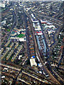
1
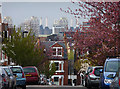
View from Kestrel Avenue
The facing house is on Fawnbrake Avenue. Beyond are the unmistakeable chimneys of Battersea Power Station (Image]). In front are three tower blocks just off Clapham Road near Stockwell.
Image: © Stephen Richards
Taken: 6 Apr 2012
0.13 miles
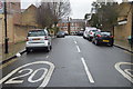
2
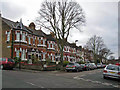
Fawnbrake Avenue, Herne Hill
Looking south west from the junction with Poplar Walk.
Image: © Richard Dorrell
Taken: 25 Dec 2011
0.16 miles
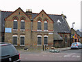
3
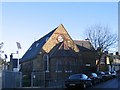
Former St John's church, Lowden Road
Built in 1880 as St John's Mission, Camberwell and later known as St John's church, Herne Hill. Now a nursery.
Image: © Stephen Craven
Taken: 21 Nov 2006
0.16 miles
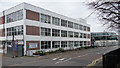
4
Milkwood Road, Herne Hill, from the train
Image: © Christopher Hilton
Taken: 7 Jun 2011
0.16 miles
5
Brixton from the air
Looking straight up Shakespeare Road from a London City bound flight from Glasgow.
The distinctive shape of Zaha Hadid's Evelyn Grace Academy Image can be seen to the left of centre.
Image: © Thomas Nugent
Taken: 6 Feb 2012
0.17 miles
6
St John's Hall, Heron Road
Located on the junction of Heron Road (on the right) and Lowden Road. The building is a late Victorian hall (built about 1880) of traditional brick construction under a pitched slate roof. Although never consecrated, the building was used for worship until 1981, and was originally known as Camberwell St John's Mission. It was able to seat 300 people. The hall was used as a Community Centre from 1990. More recently it has been occupied by a children's nursery. The hall is currently for sale, and is likely to be improved and converted for community use.
Image: © Richard Dorrell
Taken: 25 Dec 2011
0.18 miles
8
Depot, Shakespeare Road
A Lambeth Council vehicle depot I believe.
Its swankier neighbour is the Evelyn Grade Academy (see here: Image]).
Image: © Stephen Richards
Taken: 6 Mar 2011
0.18 miles
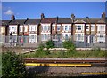
9
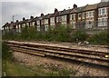
Milkwood Road
Row of terraced houses in Milkwood Road alongside railway line.
Image: © Alan Hughes
Taken: 11 Aug 2017
0.18 miles
10
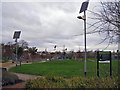
Milkwood Community Park
Viewed from an entrance from Heron Road. The facilities and features of the park include: children's playground, 5-a-side football pitch, basketball court, quiet area, trim trail, wildlife areas, and amphitheatre. Since 2003, over £500,000 has been invested to date to enable the park to offer local people of all ages and interests with a wide range of facilities for play, sport and social relaxation. In 2006 the park became Lambeth's first Green Flag Award site.
Image: © Richard Dorrell
Taken: 25 Dec 2011
0.19 miles