IMAGES TAKEN NEAR TO
Matlock Close, LONDON, SE24 0BB
Introduction
This page details the photographs taken nearby to Matlock Close, SE24 0BB by members of the Geograph project.
The Geograph project started in 2005 with the aim of publishing, organising and preserving representative images for every square kilometre of Great Britain, Ireland and the Isle of Man.

There are currently over 7.5m images from over14,400 individuals and you can help contribute to the project by visiting https://www.geograph.org.uk
Image Map
Images are licensed for reuse under creativecommons.org/licenses/by-sa/2.0
Notes
- Clicking on the map will re-center to the selected point.
- The higher the marker number, the further away the image location is from the centre of the postcode.
Image Listing (57 Images Found)
Images are licensed for reuse under creativecommons.org/licenses/by-sa/2.0
Image
Details
Distance
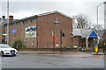
4
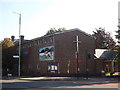
Herne Hill United Church
On the junction of the A215 Denmark Hill (on the left) and Red Post Hill (on the right).
Image: © David Anstiss
Taken: 2 Oct 2011
0.07 miles

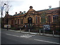
10
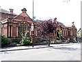
Carnegie Library, Herne Hill Road
An attractive building, due in no small part to the extensive use of terracotta. It was designed by Wakeford & Son in 1904. Grade II listed.
Image: © Stephen Richards
Taken: 8 Aug 2009
0.08 miles