IMAGES TAKEN NEAR TO
Herne Hill Road, LONDON, SE24 0AU
Introduction
This page details the photographs taken nearby to Herne Hill Road, SE24 0AU by members of the Geograph project.
The Geograph project started in 2005 with the aim of publishing, organising and preserving representative images for every square kilometre of Great Britain, Ireland and the Isle of Man.

There are currently over 7.5m images from over14,400 individuals and you can help contribute to the project by visiting https://www.geograph.org.uk
Image Map
Images are licensed for reuse under creativecommons.org/licenses/by-sa/2.0
Notes
- Clicking on the map will re-center to the selected point.
- The higher the marker number, the further away the image location is from the centre of the postcode.
Image Listing (48 Images Found)
Images are licensed for reuse under creativecommons.org/licenses/by-sa/2.0
Image
Details
Distance
1
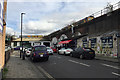
Padfield Road, Camberwell, south London
Businesses in the railway arches and alongside form a little ecosystem – cab hire, car servicing, MOT test centre, a café and a takeaway. A container freight train heads west through Loughborough Junction (where from, where to?).
Image: © Robin Stott
Taken: 20 Feb 2017
0.02 miles
2
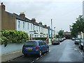
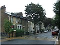
Padfield road
Padfield road leading up to the railway bridge
Image: © Shaun Ferguson
Taken: 18 Sep 2008
0.07 miles
3
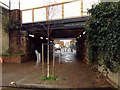
"Today is Your Day"
Walkway under the railway that splits Cambria Road in half.
Image: © Neil Theasby
Taken: 24 Jan 2016
0.07 miles
4

Scrapyard below viaduct, Loughborough Junction, from the railway
Image: © Christopher Hilton
Taken: 20 May 2014
0.07 miles
6

Light industrial premises by the railway line, south of Loughborough Junction
Image: © Christopher Hilton
Taken: 20 May 2014
0.07 miles
8
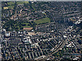
Brixton from the air
King's College Hospital is on the left, Loughborough railway junction and station are on the right.
Image: © Thomas Nugent
Taken: 22 Jun 2015
0.08 miles
9
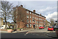
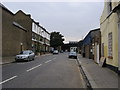
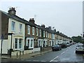
Block of 16 flats, Southwell Road, Camberwell, south London
A post-war contribution to an area of mixed uses including housing of various periods from the 19th century onwards.
Image: © Robin Stott
Taken: 20 Feb 2017
0.08 miles