IMAGES TAKEN NEAR TO
Herne Hill Road, LONDON, SE24 0AH
Introduction
This page details the photographs taken nearby to Herne Hill Road, SE24 0AH by members of the Geograph project.
The Geograph project started in 2005 with the aim of publishing, organising and preserving representative images for every square kilometre of Great Britain, Ireland and the Isle of Man.

There are currently over 7.5m images from over14,400 individuals and you can help contribute to the project by visiting https://www.geograph.org.uk
Image Map
Images are licensed for reuse under creativecommons.org/licenses/by-sa/2.0
Notes
- Clicking on the map will re-center to the selected point.
- The higher the marker number, the further away the image location is from the centre of the postcode.
Image Listing (57 Images Found)
Images are licensed for reuse under creativecommons.org/licenses/by-sa/2.0
Image
Details
Distance
2
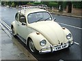
Vintage 1975 Volkswagen Beetle, Herne Hill Road
Image: © Chris Whippet
Taken: 23 Aug 2015
0.02 miles
3
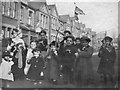
Armistice celebration 1918, Herne Hill, London
Children celebrating in Oakbank Grove.
The date is assumed to be 11th November 1918.
The photographer unknown.
The eyewitnesstohistory.com website states:
“All over the world on November 11, 1918, people were celebrating, dancing in the streets, drinking champagne, hailing the armistice that meant the end of the war. But at the front there was no celebration.”
Image: © Unknown
Taken: 11 Nov 1918
0.04 miles
7
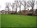
Christmas morning walkies
Cupar the Collie is experiencing a London park for the first time - it's very different to the Skye forests and moors which he is more used to - but he seems to be enjoying himself just as much.
The park is Ruskin Park, Herne Hill. The houses on the right are in Herne Hill Road, while the pair of semis on the far left are in Ferndean Road.
Image: © Richard Dorrell
Taken: 25 Dec 2011
0.06 miles
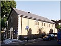
8
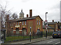
St Saviour's Church, Ruskin Park, Herne Hill
The building bears a carved inscription above the central arch declaring it to be St Saviour's Parish Hall, but a modern sign within the grounds proclaims that the building is now a Church of England church. The original St Saviour's Church (built 1867) stood a little to north of the Parish Hall. The site is now occupied by St Saviour's Primary School. The original church was demolished in 1981.
Image: © Richard Dorrell
Taken: 25 Dec 2011
0.07 miles
9

St. Philip and St. James Roman Catholic Church, Poplar Walk
The church stands on the junction with Lowden Road. The building was erected in 1905 and is a simple stock brick building with open pedimented east and west gables and a slate roof. A five-bay round-arched arcade built on the north side was intended to lead to an aisle but this extension has never been made. The architect was probably F. W. Tasker.
Image: © Richard Dorrell
Taken: 25 Dec 2011
0.07 miles
10
St.Philip and James Catholic Church, Brixton
On the junction of Popular Walk (on left) and Lowden Road.
Image: © David Anstiss
Taken: 2 Oct 2011
0.07 miles