IMAGES TAKEN NEAR TO
Grassmount, LONDON, SE23 3UW
Introduction
This page details the photographs taken nearby to Grassmount, SE23 3UW by members of the Geograph project.
The Geograph project started in 2005 with the aim of publishing, organising and preserving representative images for every square kilometre of Great Britain, Ireland and the Isle of Man.

There are currently over 7.5m images from over14,400 individuals and you can help contribute to the project by visiting https://www.geograph.org.uk
Image Map (Loading...)


Getting Data...Please wait
Leaflet Map data © OpenStreetMap
Images are licensed for reuse under creativecommons.org/licenses/by-sa/2.0
Notes
- Clicking on the map will re-center to the selected point.
- The higher the marker number, the further away the image location is from the centre of the postcode.
Image Listing (164 Images Found)
Images are licensed for reuse under creativecommons.org/licenses/by-sa/2.0
Image
Details
Distance
1

Converted church, Taymount Rise, SE23 (2)
See also Image
Image: © Mike Quinn
Taken: 4 Jul 2008
0.06 miles
2
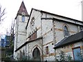
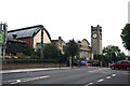
Converted church, Taymount Rise
Originally a Congregational church until 1939, thereafter a Spiritualist church until 1950, then Anglican as St Paul's. From the late 1980's a New Testament Assembly and finally sold in 1996 for conversion to residential use.
Image: © Stephen Craven
Taken: 11 Feb 2006
0.07 miles
3
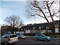
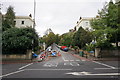
Houses with a stepped appearance on London Road
Looking south-southeast.
Image: © Robert Lamb
Taken: 27 Jan 2013
0.11 miles
4
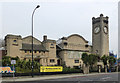
Horniman Museum, Forest Hill
Built 1902 to the designs of architect Charles Harrison Townsend (1851-1928). An interesting amalgam of Arts & Crafts and Art Nouveau influences. A Grade II* listed building, described at this https://historicengland.org.uk/listing/the-list/list-entry/1079996 . To find out more about the architect follow this http://www.victorianweb.org/victorian/art/architecture/townsend/index.html.
Image: © Jim Osley
Taken: 3 Apr 2014
0.11 miles
5
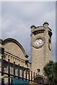
Forest Hill : clock tower, Horniman Museum
The Horniman Museum built in 1902 to a design by architect Charles Harrison Townsend. Grade II* list -https://historicengland.org.uk/listing/the-list/list-entry/1079996.
Image: © Jim Osley
Taken: 31 Jul 2019
0.11 miles
6
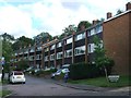
Taymount Rise
A leafy road in the older part of Forest Hill.
Image: © Bill Boaden
Taken: 11 Oct 2014
0.11 miles
7
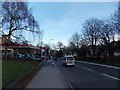
View down the hill on London Road
Looking east towards the junction with Honor Oak Road.
Image: © Robert Lamb
Taken: 27 Jan 2013
0.12 miles
10
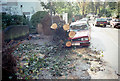
Aftermath of the 1987 "Great Storm"
Photo shows the scene in Taymount Rise near the London Road junction.
Image: © David Wright
Taken: 16 Oct 1987
0.12 miles