IMAGES TAKEN NEAR TO
Wood Vale, LONDON, SE23 3EA
Introduction
This page details the photographs taken nearby to Wood Vale, SE23 3EA by members of the Geograph project.
The Geograph project started in 2005 with the aim of publishing, organising and preserving representative images for every square kilometre of Great Britain, Ireland and the Isle of Man.

There are currently over 7.5m images from over14,400 individuals and you can help contribute to the project by visiting https://www.geograph.org.uk
Image Map
Images are licensed for reuse under creativecommons.org/licenses/by-sa/2.0
Notes
- Clicking on the map will re-center to the selected point.
- The higher the marker number, the further away the image location is from the centre of the postcode.
Image Listing (98 Images Found)
Images are licensed for reuse under creativecommons.org/licenses/by-sa/2.0
Image
Details
Distance
1
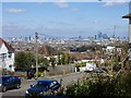
View from the Horniman Ridge
View from the corner of Ringmore Rise and Liphook Crescent. The high rise development of The City is seen to the right following over to Waterloo and the London Eye.
Image: © Brian Whittle
Taken: 4 Apr 2020
0.03 miles
2
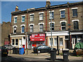
Former post office, Forest Hill
The sign in the brickwork above the present "Wood Vale News" reads "Forest Hill Woodvale Post Office". It appears to have closed c.2004 (source: http://www.se23.com/forum-archive/messages/9/141.html as found by fellow contributor David Anstiss)
Image: © Stephen Craven
Taken: 8 Jun 2008
0.05 miles
3
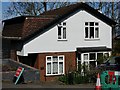
Honor Oak Station master's house
The only surviving part of Honor Oak Station is this building which was the station master's house. Honor Oak Station was on the Nunhead to Crystal Palace High Level line, which closed in 1954. Blocks of flats now occupy the site of the station itself.
Image: © Brian Whittle
Taken: 4 Apr 2020
0.07 miles
4
Canonbie Road, SE23
Canonbie Road in Honor Oak, in South East London, on a sunny day in early October.
In this image, the towers of Canary Wharf are visible in the background above the rooftop of the white building.
Image: © Malc McDonald
Taken: 4 Oct 2015
0.07 miles
5
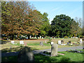
In Camberwell Cemetery
The cemetery, at least in its newer parts, is pleasantly informal in its layout.
Image: © Robin Webster
Taken: 1 Oct 2011
0.08 miles
6
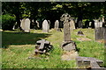
Camberwell Old Cemetery
An interesting variety of gravestones.
Image: © Peter Trimming
Taken: 14 Jul 2022
0.08 miles
7
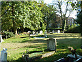
Camberwell Old Cemetery
Despite its name, this is still used - a very well attended burial was just about to begin.
Image: © Robin Webster
Taken: 1 Oct 2011
0.08 miles
8
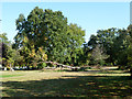
Fallen tree, Camberwell Cemetery
There is quite a lot of open space in the cemetery.
Image: © Robin Webster
Taken: 1 Oct 2011
0.09 miles
9
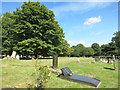
Camberwell Old Cemetery
The first interment here was on July 3rd 1856 and the cemetery is still in use today. https://en.wikipedia.org/wiki/Camberwell_Cemeteries
One of the Green Chain walks goes through here.
Image: © Des Blenkinsopp
Taken: 9 Aug 2016
0.09 miles
10
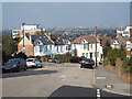
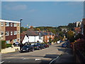
Canonbie Road, SE23
Canonbie Road climbs a ridge in South East London. There are good views over London although on the day this image was taken, conditions were slightly hazy.
Image: © Malc McDonald
Taken: 4 Oct 2015
0.10 miles