IMAGES TAKEN NEAR TO
Wood Vale, LONDON, SE23 3DT
Introduction
This page details the photographs taken nearby to Wood Vale, SE23 3DT by members of the Geograph project.
The Geograph project started in 2005 with the aim of publishing, organising and preserving representative images for every square kilometre of Great Britain, Ireland and the Isle of Man.

There are currently over 7.5m images from over14,400 individuals and you can help contribute to the project by visiting https://www.geograph.org.uk
Image Map
Images are licensed for reuse under creativecommons.org/licenses/by-sa/2.0
Notes
- Clicking on the map will re-center to the selected point.
- The higher the marker number, the further away the image location is from the centre of the postcode.
Image Listing (89 Images Found)
Images are licensed for reuse under creativecommons.org/licenses/by-sa/2.0
Image
Details
Distance
1
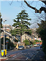
Conifer, Underhill Road
Possibly a deodar (Cedrus deodara).
Image: © Stephen Richards
Taken: 8 Dec 2012
0.11 miles
2
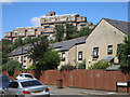
Looming over Belvoir Road
The blocks of the Dawson Heights development frown out over more traditional housing on Belvoir Road below.
Apparently, we are supposed to be thinking "Italian Hill Town" here, according to this piece from 2012. http://www.c20society.org.uk/casework/dawsons-heights-the-italian-hill-town-in-dulwich/
when there was an application for listing made. It was turned down by the Secretary of State.
From the link :-
"English Heritage disagree. They emphasise the architectural and design interest of the site: ‘The
dramatic stepped hilltop profile is a landmark in SE London, and endows the project with a striking and original massing that possesses evocative associations with ancient cities and Italian hill towns."
Err....Which Italy would that be, then....?
In fact, browsing some of the other pictures from round here, I saw this one which suggests Brazil might be a better comparison. Image
Image: © Des Blenkinsopp
Taken: 9 Aug 2016
0.13 miles
3
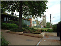
Horniman Museum SE23
Victorian tea trader Frederick John Horniman began collecting specimens and artefacts from around the world in the 1860's. He opened part of his family house to the public so they could view the riches he had collected, and eventually commissioned construction of a new museum, which opened in 1901. Entrance to the Museum and Gardens is FREE - and highly recommended! See www.horniman.ac.uk.
Image: © Philip Talmage
Taken: 21 Aug 2004
0.13 miles
4
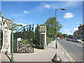
Gates to Camberwell Old Cemetery
The southern entrance onto Wood Vale.
The green signpost is a way mark for one of the Green Chain Walks, which goes through the cemetery.
Image: © Des Blenkinsopp
Taken: 9 Aug 2016
0.13 miles
5
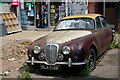
Wood Vale, Dulwich
A Daimler 2.5 V8, outside one of the shops in the parade.
Image: © Peter Trimming
Taken: 14 Jul 2022
0.14 miles
6
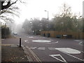
Mini-roundabout on Underhill Road
Underhill Road, heads from Lordship Lane towards East Dulwich.
Melford Road leads left towards Lordship Lane, Dulwich Park and right to Wood Vale.
Image: © David Anstiss
Taken: 20 Nov 2011
0.14 miles
7
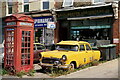
Wood Vale, Dulwich
An interesting, if somewhat confusing, scene. A Ford Consul Mark II, plus a Daimler 2.5 V8 partially hidden by the telephone box.
The shop signwriting suggests that the shop was previously a family-run butchers. However, the dust-covered displays, inside the shop, indicate that it has been an interesting car-orientated 'junk' shop for a number of years. Then there are the window stickers, 'Approved Stockists of Quality Standard Lamb', the most recent being dated 2020.
Update October 2022: this shop is still trading as a butchers, and was open as I passed.
Image: © Peter Trimming
Taken: 14 Jul 2022
0.14 miles
8

Forest Hill: an almost timeless scene on Wood Vale
This scene is probably little changed in 50-odd years – well, anyway, since 1982, the date on the shopfront sign.
Image: © Chris Downer
Taken: 19 Jan 2019
0.14 miles
9
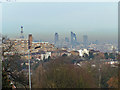
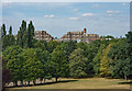
View from Horniman Gardens
View of the City with Swiss Re and the Natwest Tower with the new Shard taking place to the left. Dawson Heights flats in the middle distance. A temperature inversion has trapped the pollution in the lower air levels and this can be seen as the brown tint near ground level.
Image: © Brian Whittle
Taken: 26 Dec 2010
0.14 miles
10
East Dulwich : Dawson's Heights
Built between 1964 and 1972 to design by architect Kate Macintosh of the London Borough of Southwark.
An account of the building of this housing estate may be found at this https://municipaldreams.wordpress.com/2014/11/25/dawsons-heights-east-dulwich-an-example-of-the-almost-lost-art-of-romantic-townscape/. View from Horniman Gardens.
Image: © Jim Osley
Taken: 4 Aug 2018
0.15 miles