IMAGES TAKEN NEAR TO
Canonbie Road, LONDON, SE23 3AH
Introduction
This page details the photographs taken nearby to Canonbie Road, SE23 3AH by members of the Geograph project.
The Geograph project started in 2005 with the aim of publishing, organising and preserving representative images for every square kilometre of Great Britain, Ireland and the Isle of Man.

There are currently over 7.5m images from over14,400 individuals and you can help contribute to the project by visiting https://www.geograph.org.uk
Image Map
Images are licensed for reuse under creativecommons.org/licenses/by-sa/2.0
Notes
- Clicking on the map will re-center to the selected point.
- The higher the marker number, the further away the image location is from the centre of the postcode.
Image Listing (101 Images Found)
Images are licensed for reuse under creativecommons.org/licenses/by-sa/2.0
Image
Details
Distance
1
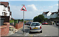
Canonbie Road - Steep Hill 18%
Canonbie Road, Forest Hill. 18% steep hill down sign.
Image: © Adam Morse
Taken: 9 Aug 2009
0.02 miles
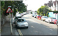
2
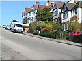
Canonbie Road SE23
With a gradient of 18%, Canonbie Road is reputed to be one of the steepest roads in London.
Image: © Brian Whittle
Taken: 10 Apr 2008
0.03 miles
3
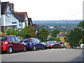
Canonbie Road, SE23
Canonbie Road, which has a gradient of 18%, looking downhill to Honor Oak Road and beyond over South East London.
Image: © Malc McDonald
Taken: 27 Jun 2010
0.03 miles
4
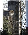
Forest Hill folly
This tower folly was built in the grounds of Tewkesbury Lodge, a large house built in the 1880s for Herbert Charles Beyer. The house was demolished around 1930 and the area developed into what is now known as the Tewkesbury Lodge estate. The house itself was where 1, Horniman Drive was built www.geograph.org.uk/photo/6432193. The folly, built of Kentish ragstone was on the ridge at the edge of the grounds with views east over South London and west over Kent. It is now a spectacular garden feature of a house in Liphook Crescent and is quite difficult to see, except through the gap between the houses.
Image: © Brian Whittle
Taken: 4 Apr 2020
0.04 miles
5
Canonbie Road - Steep Hill 18%
Canonbie Road, Forest Hill. 18% steep hill up sign.
Image: © Adam Morse
Taken: 9 Aug 2009
0.05 miles
6
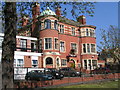
Hamilton Lodge
Like the nearby Havelock House, this was built by Charles Beyer, the owner of Tewkesbury Lodge that stood nearby. Hamilton Lodge was built around 1900 for his son. It is new a care home. Beside it is the access lane that leads up to the disused covered reservoir.
Image: © Brian Whittle
Taken: 10 Apr 2008
0.06 miles
7
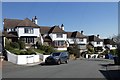
Horniman Drive group
Five detached houses line up pleasingly on a curving gradient. These have appeared in at least two television adverts.
Image: © Brian Whittle
Taken: 25 Mar 2020
0.07 miles
8
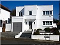
Regina - A modernist villa
The third most obvious example of 1930s modernism on the Tewkesbury Lodge Estate. See also the more flamboyant Welcome Aboard https://www.geograph.org.uk/photo/758554 and the third example just down the road https://www.geograph.org.uk/photo/6432193. Forest Hill has more than its fair share of 1930s modernist buildings as well as the Horniman Museum which is a rare example of Art Nouveau architecture in the UK.
Image: © Brian Whittle
Taken: 25 Mar 2020
0.08 miles
9
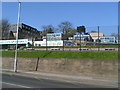
Fairlawn Primary School
Built in 1957 and designed by Peter Moro, who was instrumental in the Royal Festival Hall, the school is built on the site of a house called Fairlawn which badly damaged in WW2.
Image: © Brian Whittle
Taken: 10 Apr 2008
0.08 miles
10
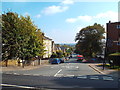
Tyson Road, SE23
Tyson Road, near Forest Hill in South East London.
Image: © Malc McDonald
Taken: 4 Oct 2015
0.08 miles