IMAGES TAKEN NEAR TO
Ewart Road, LONDON, SE23 1BE
Introduction
This page details the photographs taken nearby to Ewart Road, SE23 1BE by members of the Geograph project.
The Geograph project started in 2005 with the aim of publishing, organising and preserving representative images for every square kilometre of Great Britain, Ireland and the Isle of Man.

There are currently over 7.5m images from over14,400 individuals and you can help contribute to the project by visiting https://www.geograph.org.uk
Image Map
Images are licensed for reuse under creativecommons.org/licenses/by-sa/2.0
Notes
- Clicking on the map will re-center to the selected point.
- The higher the marker number, the further away the image location is from the centre of the postcode.
Image Listing (84 Images Found)
Images are licensed for reuse under creativecommons.org/licenses/by-sa/2.0
Image
Details
Distance
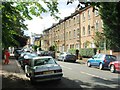
1
Houses in Bovill Road, Forest Hill
This attractive terrace is here seen from the corner of Whatman Road. They appear to be from the first half of the 19th century.
Image: © Marathon
Taken: 21 Sep 2011
0.08 miles
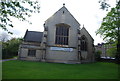
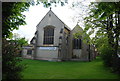
2
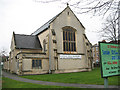
St Saviour's church, Brockley Rise
This Anglican church was built in 1862, the architect being W Smith.
It was reconstructed in 1952 following war damage.
Image: © Stephen Craven
Taken: 25 Jan 2010
0.09 miles
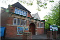
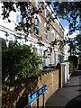
3
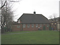
St Saviour's hall, Brockley Rise
The hall viewed from the grounds of the adjacent church Image
Image: © Stephen Craven
Taken: 25 Jan 2010
0.10 miles