IMAGES TAKEN NEAR TO
Lordship Lane, LONDON, SE22 8JZ
Introduction
This page details the photographs taken nearby to Lordship Lane, SE22 8JZ by members of the Geograph project.
The Geograph project started in 2005 with the aim of publishing, organising and preserving representative images for every square kilometre of Great Britain, Ireland and the Isle of Man.

There are currently over 7.5m images from over14,400 individuals and you can help contribute to the project by visiting https://www.geograph.org.uk
Image Map
Images are licensed for reuse under creativecommons.org/licenses/by-sa/2.0
Notes
- Clicking on the map will re-center to the selected point.
- The higher the marker number, the further away the image location is from the centre of the postcode.
Image Listing (105 Images Found)
Images are licensed for reuse under creativecommons.org/licenses/by-sa/2.0
Image
Details
Distance
1
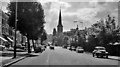
SE on Lordship Lane, near Overhill Road, London SE22, 1962
A typical South London suburb. The Church is St Peter's, designed by Charles Barry Jr.
Image: © Ben Brooksbank
Taken: 30 Aug 1962
0.02 miles
3
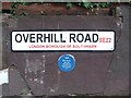
Street nameplate and Blue Plaque, Overhill Road, East Dulwich
The Blue Plaque is dedicated to the original frontman of the Rock band AC/DC Bon Scott who passed away on this street on 19th February 1980. https://en.wikipedia.org/wiki/Bon_Scott
Image: © Chris Whippet
Taken: 23 Aug 2015
0.03 miles
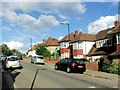
5
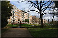
Lordship Lane Flats, East Dulwich
Looking from the eastern end of Dulwich Park. The spire of St John the Evangelist church can be seen further ahead.
Image: © Bill Boaden
Taken: 2 Feb 2014
0.07 miles
6
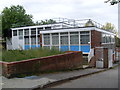
Dulwich Telephone Exchange
Located at 512 Lordship Lane (A2216 road), this TE used to have TOWnley numbers until the late 1960s. Now it has 0208-299 and 693 numbers, plus some other Outer London numbers. Its postcode is SE22 8NF.
Image: © David Hillas
Taken: 4 Oct 2011
0.08 miles
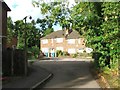
7
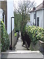
Melford Passage, SE22
Melford Passage is a short footpath from Overhill Road down to Melford Road in East Dulwich, South East London.
Image: © Malc McDonald
Taken: 3 Apr 2011
0.08 miles
9
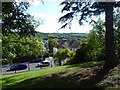
View from Dawson Heights
This is the view from the driveway leading up to the flats known as Dawson's Heights. The parkland on the other side of the flats has one of the finest views in London - see http://www.geograph.org.uk/photo/2635879. This is the south-facing side looking down to Overhill Road and beyond to Sydenham Hill Woods and Dulwich Woods. The Crystal Place TV Transmitter can be seen on the horizon above the house.
The estate at Dawson’s Heights was constructed between 1968 and 1972 and cost in total a little over £1.6 million to build. For more information about Dawson’s Heights see https://municipaldreams.wordpress.com/2014/11/25/dawsons-heights-east-dulwich-an-example-of-the-almost-lost-art-of-romantic-townscape/ and http://www.dulwichsociety.com/newsletters/43-spring-2006/213-dawsons-hill-before-daswons-heights and https://www.failedarchitecture.com/dawsons-heights-south-london-sublime/
The view of Dawson's Heights from Dawson's Hill can be seen at http://www.geograph.org.uk/photo/5407257
Image: © Marathon
Taken: 21 Sep 2011
0.09 miles
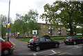
10
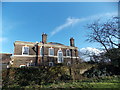
View of a house in Dulwich Park #2
Looking north-northeast.
Image: © Robert Lamb
Taken: 27 Jan 2013
0.09 miles