IMAGES TAKEN NEAR TO
Hayes Grove, LONDON, SE22 8DF
Introduction
This page details the photographs taken nearby to Hayes Grove, SE22 8DF by members of the Geograph project.
The Geograph project started in 2005 with the aim of publishing, organising and preserving representative images for every square kilometre of Great Britain, Ireland and the Isle of Man.

There are currently over 7.5m images from over14,400 individuals and you can help contribute to the project by visiting https://www.geograph.org.uk
Image Map
Images are licensed for reuse under creativecommons.org/licenses/by-sa/2.0
Notes
- Clicking on the map will re-center to the selected point.
- The higher the marker number, the further away the image location is from the centre of the postcode.
Image Listing (56 Images Found)
Images are licensed for reuse under creativecommons.org/licenses/by-sa/2.0
Image
Details
Distance
1
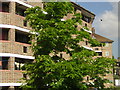
East Dulwich estate, from the train
Once local authorities were empowered in the late 19th century to build housing for rent, the London County Council were quick on the scene. The East Dulwich estate was one of their earliest tenement-style estates (the very earliest were Boundary Street in Shoreditch, and Millbank in Westminster; the earliest cottage-style estate was Totterdown Fields in Tooting). The deep slots on the access balconies are characteristic.
Image: © Christopher Hilton
Taken: 2 Jun 2011
0.07 miles
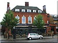
2
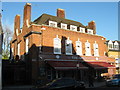
The Vale Public House
On Grove Vale, opposite Derwent Grove.
Image: © David Anstiss
Taken: 26 Nov 2010
0.07 miles
5
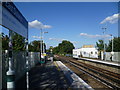
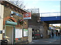
East Dulwich station
East Dulwich station was opened in 1868 by the London, Brighton & South Coast Railway as part of their line from London Bridge to Tulse Hill. When it was first opened the station was named Champion Hill. This view looks from the up platyform across the bridge over Dog Kennel Hill. There is no connecting bridge or subway between the platforms. Instead there are two separate ramps up from the road with the ticket office by the ramp leading up to the down platform.
Image: © Marathon
Taken: 14 Sep 2011
0.09 miles
6
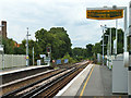
On East Dulwich station
Looking in the up direction from platform 2.
Image: © Robin Webster
Taken: 23 Jul 2011
0.09 miles
8
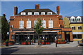
The Cherry Tree, East Dulwich
Previously called the Vale - see Image
Image: © Ian Taylor
Taken: 22 Sep 2014
0.10 miles
9
East Dulwich Station
On the A2216 Grove Vale.
Image: © David Anstiss
Taken: 26 Nov 2010
0.10 miles
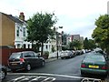
10
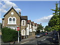
Oglander Road, SE22
Oglander Road in East Dulwich. A one-way traffic prevents this residential road being used as a short-cut between main roads.
Image: © Malc McDonald
Taken: 17 Oct 2010
0.10 miles