IMAGES TAKEN NEAR TO
East Dulwich Estate, LONDON, SE22 8AR
Introduction
This page details the photographs taken nearby to East Dulwich Estate, SE22 8AR by members of the Geograph project.
The Geograph project started in 2005 with the aim of publishing, organising and preserving representative images for every square kilometre of Great Britain, Ireland and the Isle of Man.

There are currently over 7.5m images from over14,400 individuals and you can help contribute to the project by visiting https://www.geograph.org.uk
Image Map
Images are licensed for reuse under creativecommons.org/licenses/by-sa/2.0
Notes
- Clicking on the map will re-center to the selected point.
- The higher the marker number, the further away the image location is from the centre of the postcode.
Image Listing (56 Images Found)
Images are licensed for reuse under creativecommons.org/licenses/by-sa/2.0
Image
Details
Distance
1
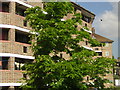
Dog Kennel Hill flats
Blocks of flats on Dog Kennel Hill.
Image: © Malc McDonald
Taken: 13 Mar 2010
0.02 miles
2
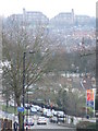
Dog Kennel Hill
Looking down Dog Kennel Hill. On the horizon are the twin blocks of Dawson Heights.
Dog Kennel Hill is a dual carriageway, this dating from the days of trams. Because of the gradient, two trams were not allowed to be on the same track on the hill at the same time, therefore two tracks were provided in each direction.
Image: © Malc McDonald
Taken: 13 Mar 2010
0.04 miles
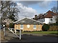
3
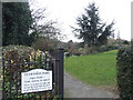
St Francis Park
Entrance to St Francis Park, next to Sainsbury's on Dog Kennel Hill.
Image: © Malc McDonald
Taken: 13 Mar 2010
0.07 miles
4

Dulwich: Dog Kennel Hill
Looking up the hill, which is part of the A2216. When trams ran here, there were four tracks on the hill, the reason being fear of a car running away on the steep gradient.
Image: © Dr Neil Clifton
Taken: 9 Jul 2012
0.07 miles
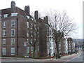
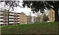
6
East Dulwich estate, from the train
Once local authorities were empowered in the late 19th century to build housing for rent, the London County Council were quick on the scene. The East Dulwich estate was one of their earliest tenement-style estates (the very earliest were Boundary Street in Shoreditch, and Millbank in Westminster; the earliest cottage-style estate was Totterdown Fields in Tooting). The deep slots on the access balconies are characteristic.
Image: © Christopher Hilton
Taken: 2 Jun 2011
0.10 miles
7
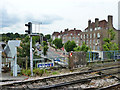
View from East Dulwich station
Looking up Dog Kennel Hill (A2216).
Image: © Robin Webster
Taken: 23 Jul 2011
0.10 miles
8
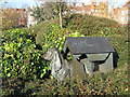
Dog in Dog Kennel
Metal sculpture in a shrub bed in St Francis Park, on Dog Kennel Hill.
Image: © David Anstiss
Taken: 26 Nov 2010
0.11 miles
9
Birdsall House and Holderness House, Champion Hill Estate, Camberwell, London
Leconfield House, the most distant, shows in part. In the 1870s there were huge houses along Champion Hill, behind the camera and to the right, with long gardens stretching downhill. The mature trees are a legacy from that time. By 1896 the largest house had gone. The open hillside sloped down to cricket, lawn tennis and athletics grounds. It may be that King's College Hospital had a hand in all this. The Champion Hill Estate, presumably built by London County Council, first appears on a map of 1954-1960 and is still there after about 60 years.
Image: © Robin Stott
Taken: 21 Feb 2017
0.14 miles
10
House on Champion Hill, Camberwell
Or technically on Langford Green, seen from Champion Hill, and looking at first sight much older than the semis behind it, which face Grove Lane. But this lodge-like single-storey house is dated 1968.
Image: © Derek Harper
Taken: 11 Mar 2011
0.14 miles