IMAGES TAKEN NEAR TO
Therapia Road, LONDON, SE22 0SD
Introduction
This page details the photographs taken nearby to Therapia Road, SE22 0SD by members of the Geograph project.
The Geograph project started in 2005 with the aim of publishing, organising and preserving representative images for every square kilometre of Great Britain, Ireland and the Isle of Man.

There are currently over 7.5m images from over14,400 individuals and you can help contribute to the project by visiting https://www.geograph.org.uk
Image Map
Images are licensed for reuse under creativecommons.org/licenses/by-sa/2.0
Notes
- Clicking on the map will re-center to the selected point.
- The higher the marker number, the further away the image location is from the centre of the postcode.
Image Listing (95 Images Found)
Images are licensed for reuse under creativecommons.org/licenses/by-sa/2.0
Image
Details
Distance
2
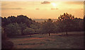
Sunset - One Tree Hill - c1965
This view would be very different in 2007 following the construction of Canary Wharf and many other high-rise buildings. Picture scanned from a rather dusty old slide.
Image: © David Wright
Taken: Unknown
0.11 miles
3
View from Brenchley Gardens
Looking over the Honor Oak Pumping Station water reservoir (also the Aquarius Golf Course).
In the middle of the background, is the London Eye.
Image: © David Anstiss
Taken: 25 Sep 2011
0.11 miles
4

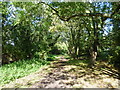
Paths in Brenchley Gardens
The Green Chain Walk (long distance path) leads through the long strip of open-space beside Brenchley Gardens (road) heading towards Forest Hill Road.
One path leads up towards the road and a rose garden, while a lower path leads to the road as well.
Image: © David Anstiss
Taken: 25 Sep 2011
0.12 miles
6

Woodland path in Brenchley Gardens
A path leads from Forest Hill Road, through the open-space woodland towards Brenchley Gardens (Road).
Image: © David Anstiss
Taken: 25 Sep 2011
0.12 miles
9
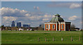
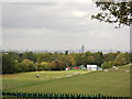
Honor Oak Reservoir
The Aquarius Golf Club was opened in 1912, making use of the land over this underground reservoir. The course commands good views over London. Canary Wharf can be seen here, with the reservoir valve house.
Image: © Ian Taylor
Taken: 17 Apr 2016
0.15 miles
10
Old railway track in Brenchley Gardens
The London, Chatham & Dover Railway opened the line from Nunhead to Crystal Palace High Level in 1865 to serve the Crystal Palace, which had been rebuilt on Sydenham Hill some ten years previously. Unfortunately the Crystal Palace was in decline as a visitor attraction by the end of the 19th century and this, coupled with the fact that the line passed through an area which was largely undeveloped well into the 20th century, meant that the line had very low passenger usage. It finally closed in 1954. Once dismantling of the track had been completed, the entire railway land between Nunhead and Crystal Palace was bought by the London County Council who passed it on to local councils for housing and open space development. This was the origin of the attractive open space known as Brenchley Gardens. This view looks northwards along the line of the old track towards Nunhead. Honor Oak station was back on the other side of Forest Hill Road - see http://www.disused-stations.org.uk/h/honor_oak/index.shtml. The Green Chain Walk now passes through Brenchley Gardens on its way to Nunhead Cemetery - see http://content.tfl.gov.uk/green-chain-walk-section-11.pdf
Image: © Marathon
Taken: 21 Sep 2011
0.15 miles