IMAGES TAKEN NEAR TO
Belvoir Road, LONDON, SE22 0QY
Introduction
This page details the photographs taken nearby to Belvoir Road, SE22 0QY by members of the Geograph project.
The Geograph project started in 2005 with the aim of publishing, organising and preserving representative images for every square kilometre of Great Britain, Ireland and the Isle of Man.

There are currently over 7.5m images from over14,400 individuals and you can help contribute to the project by visiting https://www.geograph.org.uk
Image Map
Images are licensed for reuse under creativecommons.org/licenses/by-sa/2.0
Notes
- Clicking on the map will re-center to the selected point.
- The higher the marker number, the further away the image location is from the centre of the postcode.
Image Listing (95 Images Found)
Images are licensed for reuse under creativecommons.org/licenses/by-sa/2.0
Image
Details
Distance
1
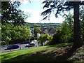
View from Dawson Heights
This is the view from the driveway leading up to the flats known as Dawson's Heights. The parkland on the other side of the flats has one of the finest views in London - see http://www.geograph.org.uk/photo/2635879. This is the south-facing side looking down to Overhill Road and beyond to Sydenham Hill Woods and Dulwich Woods. The Crystal Place TV Transmitter can be seen on the horizon above the house.
The estate at Dawson’s Heights was constructed between 1968 and 1972 and cost in total a little over £1.6 million to build. For more information about Dawson’s Heights see https://municipaldreams.wordpress.com/2014/11/25/dawsons-heights-east-dulwich-an-example-of-the-almost-lost-art-of-romantic-townscape/ and http://www.dulwichsociety.com/newsletters/43-spring-2006/213-dawsons-hill-before-daswons-heights and https://www.failedarchitecture.com/dawsons-heights-south-london-sublime/
The view of Dawson's Heights from Dawson's Hill can be seen at http://www.geograph.org.uk/photo/5407257
Image: © Marathon
Taken: 21 Sep 2011
0.03 miles
2
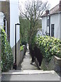
Melford Passage, SE22
Melford Passage is a short footpath from Overhill Road down to Melford Road in East Dulwich, South East London.
Image: © Malc McDonald
Taken: 3 Apr 2011
0.03 miles
3
Bredinghurst view
This is one of the views from the second floor of Bredinghurst.
Image: © terry joyce
Taken: 4 Nov 2012
0.04 miles
4
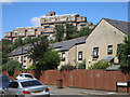
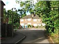
Looming over Belvoir Road
The blocks of the Dawson Heights development frown out over more traditional housing on Belvoir Road below.
Apparently, we are supposed to be thinking "Italian Hill Town" here, according to this piece from 2012. http://www.c20society.org.uk/casework/dawsons-heights-the-italian-hill-town-in-dulwich/
when there was an application for listing made. It was turned down by the Secretary of State.
From the link :-
"English Heritage disagree. They emphasise the architectural and design interest of the site: ‘The
dramatic stepped hilltop profile is a landmark in SE London, and endows the project with a striking and original massing that possesses evocative associations with ancient cities and Italian hill towns."
Err....Which Italy would that be, then....?
In fact, browsing some of the other pictures from round here, I saw this one which suggests Brazil might be a better comparison. Image
Image: © Des Blenkinsopp
Taken: 9 Aug 2016
0.04 miles
5
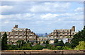
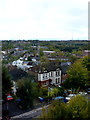
View from Horniman Museum Gardens, Forest Hill
The flats are Dawson's Heights in Overhill Road, East Dulwich. The estate, designed by Kate Mackintosh and built between 1968 and 1972, provides 296 homes.
Image: © pam fray
Taken: 3 Aug 2016
0.05 miles
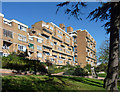
6
Dawson's Heights, East Dulwich
Seen from Horniman Gardens: for details and a wider view, see Image
Image: © Paul Harrop
Taken: 27 Oct 2017
0.05 miles
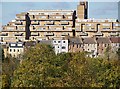
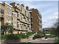
7
Dawson's Heights, Overhill Road (1)
A landmark building due to its elevated position, its craggy, stepped silhouette appearing as a man-made extension to the hill atop which it stands. Its 300 flats, each with its own balcony, are in two parallel ranges separated by a green space. In contrast to many public housing projects of the time - it was built in 1964-72 - it is clad in brown brick. Designed by Southwark Architect's Department. A listing application in 2012 by the Twentieth Century Society was rejected despite being supported by English Heritage.
Image: © Stephen Richards
Taken: 1 Nov 2014
0.07 miles
8
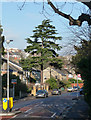
Conifer, Underhill Road
Possibly a deodar (Cedrus deodara).
Image: © Stephen Richards
Taken: 8 Dec 2012
0.07 miles
9
Dawson Heights, SE22
Two blocks of flats were built at Dawson Heights in 1972. They dominate the skyline, as can be seen in images Image and Image
Image: © Malc McDonald
Taken: 3 Apr 2011
0.08 miles