IMAGES TAKEN NEAR TO
Underhill Road, LONDON, SE22 0PD
Introduction
This page details the photographs taken nearby to Underhill Road, SE22 0PD by members of the Geograph project.
The Geograph project started in 2005 with the aim of publishing, organising and preserving representative images for every square kilometre of Great Britain, Ireland and the Isle of Man.

There are currently over 7.5m images from over14,400 individuals and you can help contribute to the project by visiting https://www.geograph.org.uk
Image Map
Images are licensed for reuse under creativecommons.org/licenses/by-sa/2.0
Notes
- Clicking on the map will re-center to the selected point.
- The higher the marker number, the further away the image location is from the centre of the postcode.
Image Listing (86 Images Found)
Images are licensed for reuse under creativecommons.org/licenses/by-sa/2.0
Image
Details
Distance
1
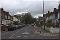
Junction of Dunstan's Road and Underhill Road
Image: © Robert Eva
Taken: 14 Jan 2019
0.04 miles
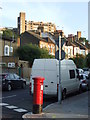
2
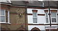
Dunstan's Road clock.
Telling the right time too.
Image: © Robert Eva
Taken: 14 Jan 2019
0.04 miles
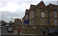
4
Goodrich Road, East Dulwich
Goodrich Road at the junction with Dunstan's Road.
Image: © Malc McDonald
Taken: 27 Jun 2010
0.09 miles
5
Street corner in East Dulwich
The corner of Dunstan's Road and Goodrich Road. In the background is one of the twin blocks of Dawson Heights, built in 1972 and a prominent feature of the local skyline.
Image: © Malc McDonald
Taken: 27 Jun 2010
0.11 miles
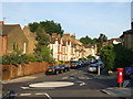
6
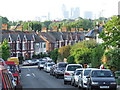
Dunstan's Road, East Dulwich
View northwards along Dunstan's Road, with the towers of the City visible in the background.
Image: © Malc McDonald
Taken: 27 Jun 2010
0.12 miles
8
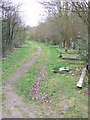
Path, Camberwell Old Cemetery
A path in the northern part of the cemetery. A notice warns that graves in this area may be unsafe.
Image: © Derek Harper
Taken: 11 Mar 2011
0.15 miles
9
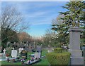
Camberwell Old Cemetery
Originally meadow land, this was part of the second wave of mid-19th century cemeteries aimed at solving the problem of overcrowding in London's churchyards. The first interment took place on 3 July 1856.
Image: © Paul Coueslant
Taken: 19 Dec 2018
0.15 miles
10
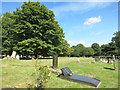
Camberwell Old Cemetery
The first interment here was on July 3rd 1856 and the cemetery is still in use today. https://en.wikipedia.org/wiki/Camberwell_Cemeteries
One of the Green Chain walks goes through here.
Image: © Des Blenkinsopp
Taken: 9 Aug 2016
0.16 miles