IMAGES TAKEN NEAR TO
Piermont Green, LONDON, SE22 0LP
Introduction
This page details the photographs taken nearby to Piermont Green, SE22 0LP by members of the Geograph project.
The Geograph project started in 2005 with the aim of publishing, organising and preserving representative images for every square kilometre of Great Britain, Ireland and the Isle of Man.

There are currently over 7.5m images from over14,400 individuals and you can help contribute to the project by visiting https://www.geograph.org.uk
Image Map
Images are licensed for reuse under creativecommons.org/licenses/by-sa/2.0
Notes
- Clicking on the map will re-center to the selected point.
- The higher the marker number, the further away the image location is from the centre of the postcode.
Image Listing (74 Images Found)
Images are licensed for reuse under creativecommons.org/licenses/by-sa/2.0
Image
Details
Distance
2

Course of the River Peck
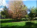
In the 19th century what is now Peckham Rye Park was Homestall Farm. The land for Peckham Rye Park was purchased by the London County Council for £51,000 and declared open on 14 May 1894. Along the west side of the park here, next to Peckham Rye, flowed the River Peck along a new course, after it had been enclosed in 1823. This river rose just to the south of here and after leaving Peckham Rye Park and Common it eventually flowed under the Old Kent Road to the east of Asylum Road before joining another river known as the Earl's Sluice. The combined river joined the Thames at Deptford, where it was widened to form South Dock. This part of Peckham Rye Park can still be very marshy. Where I was standing to take the photograph was very wet and there was a small pond around the tree.
However, the River Peck has now been landscaped into the park as a feature, following its original course further east leading from Homestall Road as seen here https://www.google.com/maps/@51.4584442,-0.0618155,16.75z
Image: © Marathon
Taken: 21 Sep 2011
0.04 miles
3
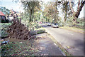
Aftermath of the 1987 "Great Storm"
Photo shows downed tree on Peckham Rye near Piermont Green.
Image: © David Wright
Taken: 16 Oct 1987
0.05 miles
4

Valley of the River Peck, Peckham Rye Park
In the 19th century what is now Peckham Rye Park was Homestall Farm. The land for Peckham Rye Park was purchased by the London County Council for £51,000 and declared open on 14 May 1894. Along the west side of the park here, next to Peckham Rye, flowed the River Peck along a new course, after it had been enclosed in 1823. This river rose just to the south of here and after leaving Peckham Rye Park and Common it eventually flowed under the Old Kent Road to the east of Asylum Road before joining another river known as the Earl's Sluice. The combined river joined the Thames at Deptford, where it was widened to form South Dock. This part of Peckham Rye Park can still be very marshy. Where I was standing to take the photograph was very wet and there was a small pond around the tree.
However, the River Peck has now been landscaped into the park as a feature, following its original course further east leading from Homestall Road as seen here https://www.google.com/maps/@51.4584442,-0.0618155,16.75z
Image: © Marathon
Taken: 21 Sep 2011
0.05 miles
5
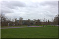
Peckham Rye Park, looking towards Harris Boys Academy
Image: © Robert Eva
Taken: 14 Jan 2019
0.06 miles
6
Course of the River Peck in Peckham Rye Park
In the 19th century what is now Peckham Rye Park was Homestall Farm. The land for Peckham Rye Park was purchased by the London County Council for £51,000 and declared open on 14 May 1894. Along the west side of the park here, next to Peckham Rye, flowed the River Peck along a new course, after it had been enclosed in 1823. This river rose just to the south of here and after leaving Peckham Rye Park and Common it eventually flowed under the Old Kent Road to the east of Asylum Road before joining another river known as the Earl's Sluice. The combined river joined the Thames at Deptford, where it was widened to form South Dock. This part of Peckham Rye Park can still be very marshy. Where I was standing to take the photograph was very wet and there was a small pond around the tree.
However, the River Peck has now been landscaped into the park as a feature, following its original course further east leading from Homestall Road as seen here https://www.google.com/maps/@51.4584442,-0.0618155,16.75z
Image: © Marathon
Taken: 21 Sep 2011
0.06 miles
7
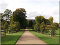
Lime Avenue in Peckham Rye Park
This path leads towards Peckham Rye.
In the background is the Harris Boys Academy.
Image: © David Anstiss
Taken: 25 Sep 2011
0.07 miles
9
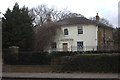
The Elms, Peckham Rye Park
This grade 2 listed building is currently used as a nursery.
Image: © Robert Eva
Taken: 14 Jan 2019
0.08 miles
10
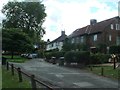
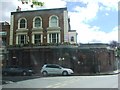
Piermont Green - 1989
Piermont Green 1989. The public house is the "Herne Tavern". Day and Month uncertain.
Image: © David Wright
Taken: Unknown
0.09 miles