IMAGES TAKEN NEAR TO
Cornflower Terrace, LONDON, SE22 0HH
Introduction
This page details the photographs taken nearby to Cornflower Terrace, SE22 0HH by members of the Geograph project.
The Geograph project started in 2005 with the aim of publishing, organising and preserving representative images for every square kilometre of Great Britain, Ireland and the Isle of Man.

There are currently over 7.5m images from over14,400 individuals and you can help contribute to the project by visiting https://www.geograph.org.uk
Image Map
Images are licensed for reuse under creativecommons.org/licenses/by-sa/2.0
Notes
- Clicking on the map will re-center to the selected point.
- The higher the marker number, the further away the image location is from the centre of the postcode.
Image Listing (80 Images Found)
Images are licensed for reuse under creativecommons.org/licenses/by-sa/2.0
Image
Details
Distance
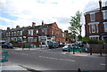
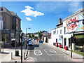
2
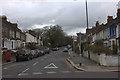
Junction of Dunstan's Road and Underhill Road
Image: © Robert Eva
Taken: 14 Jan 2019
0.06 miles
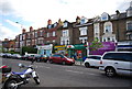
5
Dunstan's Road clock.
Telling the right time too.
Image: © Robert Eva
Taken: 14 Jan 2019
0.10 miles
7
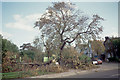
Aftermath of the 1987 "Great Storm"
Photo shows damage at the entrance to Peckham Rye Park at the corner of Forest Hill Road and Colyton Road.
Image: © David Wright
Taken: 16 Oct 1987
0.11 miles