IMAGES TAKEN NEAR TO
Upland Road, LONDON, SE22 0DE
Introduction
This page details the photographs taken nearby to Upland Road, SE22 0DE by members of the Geograph project.
The Geograph project started in 2005 with the aim of publishing, organising and preserving representative images for every square kilometre of Great Britain, Ireland and the Isle of Man.

There are currently over 7.5m images from over14,400 individuals and you can help contribute to the project by visiting https://www.geograph.org.uk
Image Map
Images are licensed for reuse under creativecommons.org/licenses/by-sa/2.0
Notes
- Clicking on the map will re-center to the selected point.
- The higher the marker number, the further away the image location is from the centre of the postcode.
Image Listing (56 Images Found)
Images are licensed for reuse under creativecommons.org/licenses/by-sa/2.0
Image
Details
Distance
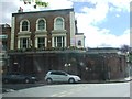
1
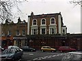
The Herne Tavern
The Herne Tavern, Piermont Green, 2000.
Image: © David Wright
Taken: 20 Dec 2000
0.04 miles
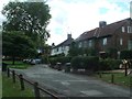
2
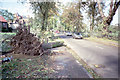
Aftermath of the 1987 "Great Storm"
Photo shows downed tree on Peckham Rye near Piermont Green.
Image: © David Wright
Taken: 16 Oct 1987
0.08 miles
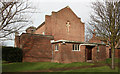
5
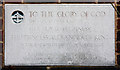
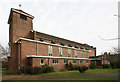
St Clement with St Peter, Friern Road - Foundation stone
Image: © John Salmon
Taken: 3 Feb 2011
0.12 miles
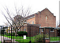
8
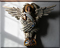
St Clement with St Peter, Friern Road - Carving
Symbol of St Matthew
Image: © John Salmon
Taken: 3 Feb 2011
0.12 miles
10
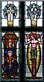
St Clement with St Peter, Friern Road - Stained glass window
Image: © John Salmon
Taken: 3 Feb 2011
0.12 miles