IMAGES TAKEN NEAR TO
Kingswood Estate, LONDON, SE21 8PX
Introduction
This page details the photographs taken nearby to Kingswood Estate, SE21 8PX by members of the Geograph project.
The Geograph project started in 2005 with the aim of publishing, organising and preserving representative images for every square kilometre of Great Britain, Ireland and the Isle of Man.

There are currently over 7.5m images from over14,400 individuals and you can help contribute to the project by visiting https://www.geograph.org.uk
Image Map
Images are licensed for reuse under creativecommons.org/licenses/by-sa/2.0
Notes
- Clicking on the map will re-center to the selected point.
- The higher the marker number, the further away the image location is from the centre of the postcode.
Image Listing (102 Images Found)
Images are licensed for reuse under creativecommons.org/licenses/by-sa/2.0
Image
Details
Distance
1
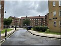
Vehicle access and car parking, west side of Kingswood Estate, East Dulwich
Looking past Holberry House, right, to Mellor House with Michaelson House to its left. The original estate layout of the 1950s had only limited vehicle access and parking: all this has been introduced.
Image: © Robin Stott
Taken: 28 Jun 2021
0.01 miles
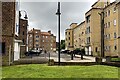
2
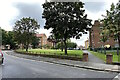
Open space by Bowen Drive, Kingswood Estate, East Dulwich
On the right is Markham House.
Image: © Robin Stott
Taken: 28 Jun 2021
0.02 miles
3
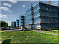
Maintenance on the Kingswood Estate, East Dulwich
Markham House is shrouded in netting.
Image: © Robin Stott
Taken: 13 May 2022
0.03 miles
4
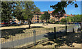
Parched grass, Kingswood Estate, East Dulwich, London
In the summer of 2022 much of Britain experienced drought.
Image: © Robin Stott
Taken: 7 Aug 2022
0.03 miles
5
Access between Hovendon House and Holberry House, Kingswood Estate
Looking south to Markham House; Hovendon House is on the left and Holberry House on the right.
Image: © Robin Stott
Taken: 28 Jun 2021
0.04 miles
6
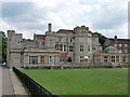
Kingswood House, Bowen Drive
By H.V. Lanchester, 1892, for L.J. Johnstone, the founder of Bovril. Built to loosely resemble a castle, it is rather plain and the stone used is not very attractive. Grade II listed.
The house is now used as a community centre for the modern housing estate which surrounds it.
Image: © Stephen Richards
Taken: 9 Aug 2009
0.04 miles
7
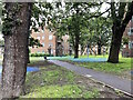
Playspace beneath old trees, Kingswod Estate, East Dulwich
The blue material is a safety surface formed of bound rubber crumbs.
Image: © Robin Stott
Taken: 28 Jun 2021
0.04 miles
8
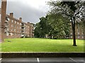
Green space enclosed by Telfer House and Markham House, Kingswood Estate
Telfer House is on the left, Markham House on the right. The angled layout of the blocks forms a semi-enclosed space whose focal point is a group of mature trees. The 1950s estate retained some of the grand old oaks that studded the grounds of Kingswood House. They create a noble and notable setting that is in scale with the blocks of flats. The map of 1958-73 shows a number of individual large trees, though fewer than the map of 1916. https://www.southwark.gov.uk/events-culture-and-heritage/explore-culture-in-southwark/heritage-and-local-history/historic-southwark/kingswood-house?chapter=2
Image: © Robin Stott
Taken: 28 Jun 2021
0.05 miles
9
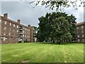
Mature trees, Kingswood Estate, East Dulwich
The angled layout of the blocks forms a semi-enclosed space whose focal point is a group of mature trees. The 1950s estate retained some of the grand old oaks that studded the grounds of Kingswood House. They create a noble and notable setting that is in scale with the blocks of flats. The map of 1958-73 shows a number of individual large trees, though fewer than the map of 1916. https://www.southwark.gov.uk/events-culture-and-heritage/explore-culture-in-southwark/heritage-and-local-history/historic-southwark/kingswood-house?chapter=2 Telfer House is on the left, Markham House on the right.
Image: © Robin Stott
Taken: 28 Jun 2021
0.05 miles
10
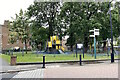
Fenced playspace at the junction of Bowen Drive and Seeley Drive, Kingswood Estate
On the left is Markham House.
Image: © Robin Stott
Taken: 28 Jun 2021
0.05 miles