IMAGES TAKEN NEAR TO
Cokers Lane, LONDON, SE21 8NF
Introduction
This page details the photographs taken nearby to Cokers Lane, SE21 8NF by members of the Geograph project.
The Geograph project started in 2005 with the aim of publishing, organising and preserving representative images for every square kilometre of Great Britain, Ireland and the Isle of Man.

There are currently over 7.5m images from over14,400 individuals and you can help contribute to the project by visiting https://www.geograph.org.uk
Image Map
Images are licensed for reuse under creativecommons.org/licenses/by-sa/2.0
Notes
- Clicking on the map will re-center to the selected point.
- The higher the marker number, the further away the image location is from the centre of the postcode.
Image Listing (144 Images Found)
Images are licensed for reuse under creativecommons.org/licenses/by-sa/2.0
Image
Details
Distance
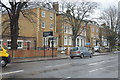
1
Pymer's Mead, West Dulwich
Part of a private estate by Croxted Road built around the late 60s/early 70s. It's nearly all town houses but this part is bungalows. Year is approximate.
Image: © David Howard
Taken: Unknown
0.01 miles
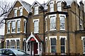
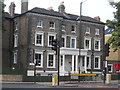
2
Oakfield school 125th anniversary
Seen from Croxted Road
Image: © Robert Eva
Taken: 16 Jan 2019
0.05 miles

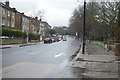
5
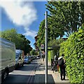
Bus stop WF, A2199 Croxted Road, West Dulwich
Schoolchildren wait for a service 3 or a 201 to take them home. The queue of traffic is waiting at the lights controlling the junction with the A205 Thurlow Park Road behind the camera – the South Circular Road.
Image: © Robin Stott
Taken: 17 May 2022
0.07 miles
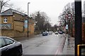
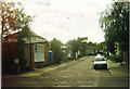
7
Oakfield Preparatory School, Thurlow Park Road
Image: © Bikeboy
Taken: 24 Jul 2013
0.07 miles
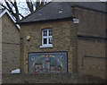
9
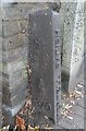
Old Boundary Marker by the A205, Thurlow Park Road
Parish Boundary Marker by the A205, in parish of Camberwell And Dulwich (Southwark District), Thurlow Park Road SE21, by Nos 122a & 120, South side of road.
To be surveyed
Milestone Society National ID: SY_SGC17pb.
Image: © Milestone Society
Taken: Unknown
0.08 miles