IMAGES TAKEN NEAR TO
Rosendale Road, LONDON, SE21 8LQ
Introduction
This page details the photographs taken nearby to Rosendale Road, SE21 8LQ by members of the Geograph project.
The Geograph project started in 2005 with the aim of publishing, organising and preserving representative images for every square kilometre of Great Britain, Ireland and the Isle of Man.

There are currently over 7.5m images from over14,400 individuals and you can help contribute to the project by visiting https://www.geograph.org.uk
Image Map
Images are licensed for reuse under creativecommons.org/licenses/by-sa/2.0
Notes
- Clicking on the map will re-center to the selected point.
- The higher the marker number, the further away the image location is from the centre of the postcode.
Image Listing (139 Images Found)
Images are licensed for reuse under creativecommons.org/licenses/by-sa/2.0
Image
Details
Distance
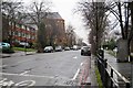
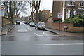
4
The South Circular Road, West Dulwich
Seen at its junction with Rosendale Road, on a typically dull day.
Image: © Bill Boaden
Taken: 13 Sep 2013
0.05 miles
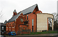
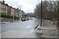
6
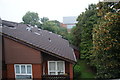
Flats in West Dulwich
The whole area has large houses, some purpose-built for flats, and others converted. This is the quiet side away from the South Circular Road. There is a glimpse of All Saints Church, West Dulwich ahead.
Image: © Bill Boaden
Taken: 13 Sep 2013
0.05 miles
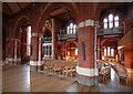
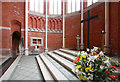
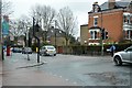
7
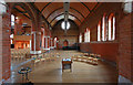
All Saints, Rosendale Road - North aisle
Image: © John Salmon
Taken: 10 Feb 2011
0.06 miles