IMAGES TAKEN NEAR TO
Rosendale Road, LONDON, SE21 8LP
Introduction
This page details the photographs taken nearby to Rosendale Road, SE21 8LP by members of the Geograph project.
The Geograph project started in 2005 with the aim of publishing, organising and preserving representative images for every square kilometre of Great Britain, Ireland and the Isle of Man.

There are currently over 7.5m images from over14,400 individuals and you can help contribute to the project by visiting https://www.geograph.org.uk
Image Map
Images are licensed for reuse under creativecommons.org/licenses/by-sa/2.0
Notes
- Clicking on the map will re-center to the selected point.
- The higher the marker number, the further away the image location is from the centre of the postcode.
Image Listing (69 Images Found)
Images are licensed for reuse under creativecommons.org/licenses/by-sa/2.0
Image
Details
Distance
1
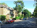
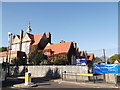
Turney Road, Dulwich
Seen from its junction with Rosendale Road. The school ahead is Rosendale Primary School which on a Sunday is the venue for Grace Church, Dulwich.
Image: © Bill Boaden
Taken: 31 Jan 2014
0.05 miles
2
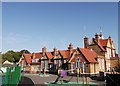
Rosendale Primary School, Herne Hill (3)
A Grade II listed school, as seen from over the wall on Turney Road.
See http://www.britishlistedbuildings.co.uk/en-204716-main-building-of-rosendale-junior-mixed- for more details about the school.
Image: © David Anstiss
Taken: 2 Oct 2011
0.08 miles
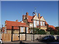
4
Rosendale Primary School, Herne Hill
A Grade II listed school, as seen from Turney Road.
See http://www.britishlistedbuildings.co.uk/en-204716-main-building-of-rosendale-junior-mixed- for more details about the school.
Image: © David Anstiss
Taken: 2 Oct 2011
0.09 miles
5
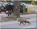
Fox, Tulse Hill
A fox trots across Rosendale Road, having successfully stopped the traffic.
Image: © Derek Harper
Taken: 11 Mar 2011
0.11 miles
6
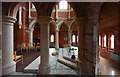
All Saints, Rosendale Road - North chapel
Image: © John Salmon
Taken: 10 Feb 2011
0.13 miles
7
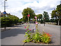
Dulwich: Road junction with flowers
This is the junction of Lovelace Road with Rosendale Road, and in an island at the junction, where a small area of earth had become exposed, a public-spirited individual has planted flowers, including hollyhocks, delphiniums and montbretia. I would like to say 'thank you' to the (probably) lady who did this, it brightened my day.
Image: © Dr Neil Clifton
Taken: 21 Jul 2012
0.13 miles
8
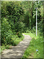
Path, Knight's Hill
This way leads down from the Peabody Hill estate to the main Peabody Estate.
Image: © Robin Webster
Taken: 23 Jul 2011
0.15 miles
9
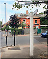
Local Signpost
There are quite a lot of these old fashioned finger posts around here. Much more stylish, though possibly harder to read, than the usual road signs.
Image: © Des Blenkinsopp
Taken: 22 Jul 2018
0.15 miles