IMAGES TAKEN NEAR TO
Thurlow Park Road, LONDON, SE21 8JP
Introduction
This page details the photographs taken nearby to Thurlow Park Road, SE21 8JP by members of the Geograph project.
The Geograph project started in 2005 with the aim of publishing, organising and preserving representative images for every square kilometre of Great Britain, Ireland and the Isle of Man.

There are currently over 7.5m images from over14,400 individuals and you can help contribute to the project by visiting https://www.geograph.org.uk
Image Map
Images are licensed for reuse under creativecommons.org/licenses/by-sa/2.0
Notes
- Clicking on the map will re-center to the selected point.
- The higher the marker number, the further away the image location is from the centre of the postcode.
Image Listing (212 Images Found)
Images are licensed for reuse under creativecommons.org/licenses/by-sa/2.0
Image
Details
Distance
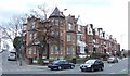
1
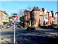
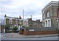
Victorian Mansions
These three storey houses are situated at the junction of Thurlow Park Rd , the A205(on the right) and Lovelace Rd (ahead). Elmcourt Rd is the road in the foreground.
Image: © Nigel Mykura
Taken: 5 Mar 2013
0.02 miles
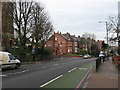
5
Thurlow Park Road
The A205 at the junction with Lovelace Road, and an impressive Victorian terrace beginning between the two roads.
Image: © Derek Harper
Taken: 11 Mar 2011
0.04 miles
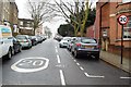
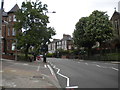
6
Pelican crossing on Thurlow Park Road
This is part of the South Circular Road, very busy at times.
Image: © Stephen Craven
Taken: 24 Feb 2011
0.04 miles
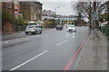
7
Thurlow Park Road, Tulse Hill
Part of the A205 South Circular road, looking towards West Dulwich. The bottom of Lovelace Road is on the left.
Image: © Richard Vince
Taken: 14 May 2016
0.04 miles
8
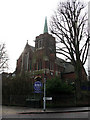
Former St Cuthbert's Church, Tulse Hill
The building was originally Saint Cuthbert's Presbyterian Church, built in 1901 on the corner of Elmcourt Road and Thurlow Park Road, Tulse Hill. In 1972 it became a United Reformed Church. It is now Rosemead Preparatory School. See also Image
Image: © Stephen Craven
Taken: 24 Feb 2011
0.04 miles
9
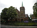
Rosemead Preparatory School, West Norwood
Formerly St Cuthbert's Presbyterian Church (later a United Reformed Church), on the corner of Elmcourt Road (right) and Thurlow Park Road. Please see Image for further historical details, and http://landmark.lambeth.gov.uk/display_page.asp?section=landmark&id=1726 for a photo from circa 1925 that shows the building when it performed its original function.
Image: © Richard Vince
Taken: 14 May 2016
0.04 miles
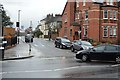
10
Houses in SE21
Birkbeck Place and Thurlow Hill at their junction with Lovelace Road. The junction is on the margins of Tulse Hill and West Dulwich.
Image: © Derek Harper
Taken: 11 Mar 2011
0.05 miles