IMAGES TAKEN NEAR TO
Carson Road, LONDON, SE21 8HT
Introduction
This page details the photographs taken nearby to Carson Road, SE21 8HT by members of the Geograph project.
The Geograph project started in 2005 with the aim of publishing, organising and preserving representative images for every square kilometre of Great Britain, Ireland and the Isle of Man.

There are currently over 7.5m images from over14,400 individuals and you can help contribute to the project by visiting https://www.geograph.org.uk
Image Map
Images are licensed for reuse under creativecommons.org/licenses/by-sa/2.0
Notes
- Clicking on the map will re-center to the selected point.
- The higher the marker number, the further away the image location is from the centre of the postcode.
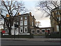
Image Listing (149 Images Found)
Images are licensed for reuse under creativecommons.org/licenses/by-sa/2.0
Image
Details
Distance
1
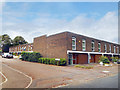
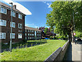
Ling's Coppice, West Dulwich
A low rise development off Croxted Road.
Image: © Des Blenkinsopp
Taken: 22 Jul 2018
0.02 miles
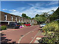
3
Ling's Coppice, private road, West Dulwich
Seen from Croxted Road.
Image: © Robin Stott
Taken: 17 May 2022
0.06 miles
4
Ling's Coppice outlook to Croxted Road, West Dulwich
Image: © Robin Stott
Taken: 17 May 2022
0.06 miles
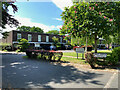
5
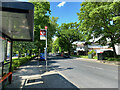
Request bus stop for Lings Coppice, Croxted Road, West Dulwich
Stop WR serves two routes, the 3 and the N3. Across the road are the Glazebrook Close and Kennoldes estates.
Image: © Robin Stott
Taken: 17 May 2022
0.07 miles
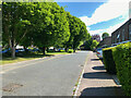
6
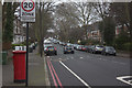
Kennoldes estate across A2199 Croxted Road, West Dulwich
The amount of traffic here is normal.
Image: © Robin Stott
Taken: 17 May 2022
0.08 miles

9
Gannet Court, Elmworth Grove estate, West Dulwich
Fronting A2199 Croxted Road.
Image: © Robin Stott
Taken: 17 May 2022
0.11 miles
10
Oakfields Preparatory School on Thurlow Park Road
Image: © David Howard
Taken: 16 Feb 2014
0.12 miles