IMAGES TAKEN NEAR TO
Park Hall Road, LONDON, SE21 8ES
Introduction
This page details the photographs taken nearby to Park Hall Road, SE21 8ES by members of the Geograph project.
The Geograph project started in 2005 with the aim of publishing, organising and preserving representative images for every square kilometre of Great Britain, Ireland and the Isle of Man.

There are currently over 7.5m images from over14,400 individuals and you can help contribute to the project by visiting https://www.geograph.org.uk
Image Map
Images are licensed for reuse under creativecommons.org/licenses/by-sa/2.0
Notes
- Clicking on the map will re-center to the selected point.
- The higher the marker number, the further away the image location is from the centre of the postcode.
Image Listing (68 Images Found)
Images are licensed for reuse under creativecommons.org/licenses/by-sa/2.0
Image
Details
Distance
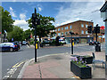
2
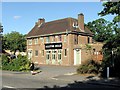
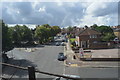
Dulwich: The 'Alleyn's Head'
Pub cum restaurant at the junction of Park Hall Road with Alleyn Park
Image: © Dr Neil Clifton
Taken: 21 Jul 2012
0.02 miles
3
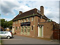
Ember Pub and Dining, West Dulwich
This pub is on the junction of Park Hall Road (in front) and Alleyn Park (road -behind).
It wasImage
Image: © David Anstiss
Taken: 2 Oct 2011
0.02 miles
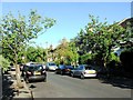
7
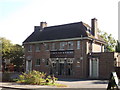
Park Hall Road, West Dulwich
Seen from the junction with Croxted Road South.
Image: © Robin Stott
Taken: 17 May 2022
0.06 miles
9
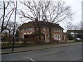
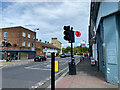
Croxted Road local shops, West Dulwich
Park Hall Road runs across the picture.
Image: © Robin Stott
Taken: 17 May 2022
0.06 miles
10
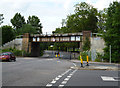
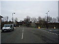
Dulwich: Railway bridge over Alleyn Park
The photographer stands on the corner of Alleyn Park, which continues under the railway bridge. The road coming in, lower left, is Park Hall Road, which ends here, while the small road behind the red car is Acacia Grove. The railway over the bridge is the ex-LCD main line from Victoria to Dover; in steam days, the 'Golden Arrow', latterly in the charge of a Bulleid Pacific, could be seen speeding over this bridge.
Image: © Dr Neil Clifton
Taken: 21 Jul 2012
0.06 miles