IMAGES TAKEN NEAR TO
Rosendale Road, LONDON, SE21 8DX
Introduction
This page details the photographs taken nearby to Rosendale Road, SE21 8DX by members of the Geograph project.
The Geograph project started in 2005 with the aim of publishing, organising and preserving representative images for every square kilometre of Great Britain, Ireland and the Isle of Man.

There are currently over 7.5m images from over14,400 individuals and you can help contribute to the project by visiting https://www.geograph.org.uk
Image Map
Images are licensed for reuse under creativecommons.org/licenses/by-sa/2.0
Notes
- Clicking on the map will re-center to the selected point.
- The higher the marker number, the further away the image location is from the centre of the postcode.
Image Listing (182 Images Found)
Images are licensed for reuse under creativecommons.org/licenses/by-sa/2.0
Image
Details
Distance
1
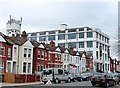
Parkhall business park, Martell Road
Looming over its neighbours, this former Pye Electronics factory, built in the 1930s in a Moderne/Art Deco style, has been converted into multiple small business units.
Image: © Stephen Richards
Taken: Unknown
0.10 miles
2
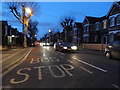
Bus stop on South Croxted Road, Dulwich
Image: © David Howard
Taken: 16 Feb 2014
0.11 miles
3
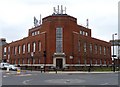
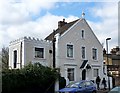
Telephone exchange, Park Hall Road
A neo-Georgian building dating from the 1930s (at a guess). An interesting shape with the centrepiece owing something to the Art Deco movement.
Image: © Stephen Richards
Taken: Unknown
0.11 miles
4
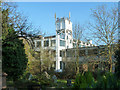
Water tower, Park Hall Road Trading Estate
A former industrial building, now subdivided, viewed from west Norwood cemetery.
Image: © Robin Webster
Taken: 19 Nov 2011
0.13 miles
5
109 Clive Road
It has been surmised that the unusually elaborate plasterwork of this house of 1882 served as an advertisement of the skills of its occupant, Ralph Gardiner. Yes, he was a plasterer.
Image: © Stephen Richards
Taken: Unknown
0.13 miles
6
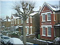
Victorian villas, South Croxted Road
From the top deck of a route 3 bus.
Image: © Christopher Hilton
Taken: 21 Jan 2013
0.13 miles
7
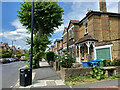
Frontage, South Croxted Road, West Dulwich
Many houses on the east side of the road feature a porch, white timber-framed.
Image: © Robin Stott
Taken: 17 May 2022
0.14 miles
8
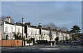
33-61 Park Hall Road
A distinctive little group, probably mid-C19th and so earlier than most of its surroundings.
The large conifer at the end can be seen here: Image
Image: © Stephen Richards
Taken: 23 Dec 2012
0.14 miles
9
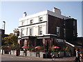
The Rosendale, Public House, West Dulwich
On the junction of Rosendale Road (in front) and Robson Road (on the left, behind the pub).
Image: © David Anstiss
Taken: 2 Oct 2011
0.15 miles
10
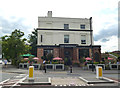
Dulwich: The 'Rosendale'
At the crossroads of Rosendale Road and Park Hall Road
Image: © Dr Neil Clifton
Taken: 21 Jul 2012
0.15 miles