IMAGES TAKEN NEAR TO
Clive Road, LONDON, SE21 8BS
Introduction
This page details the photographs taken nearby to Clive Road, SE21 8BS by members of the Geograph project.
The Geograph project started in 2005 with the aim of publishing, organising and preserving representative images for every square kilometre of Great Britain, Ireland and the Isle of Man.

There are currently over 7.5m images from over14,400 individuals and you can help contribute to the project by visiting https://www.geograph.org.uk
Image Map
Images are licensed for reuse under creativecommons.org/licenses/by-sa/2.0
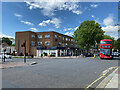
Notes
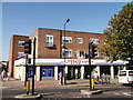
- Clicking on the map will re-center to the selected point.
- The higher the marker number, the further away the image location is from the centre of the postcode.
Image Listing (154 Images Found)
Images are licensed for reuse under creativecommons.org/licenses/by-sa/2.0
Image
Details
Distance
1
Bus stop on South Croxted Road, Dulwich
Image: © David Howard
Taken: 16 Feb 2014
0.08 miles
2
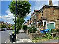
Frontage, South Croxted Road, West Dulwich
Many houses on the east side of the road feature a porch, white timber-framed.
Image: © Robin Stott
Taken: 17 May 2022
0.09 miles
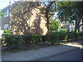
3
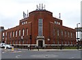
Telephone exchange, Park Hall Road
A neo-Georgian building dating from the 1930s (at a guess). An interesting shape with the centrepiece owing something to the Art Deco movement.
Image: © Stephen Richards
Taken: Unknown
0.11 miles
5
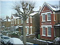
Victorian villas, South Croxted Road
From the top deck of a route 3 bus.
Image: © Christopher Hilton
Taken: 21 Jan 2013
0.11 miles
6
Elmworth Grove looking towards Park Hall Road, West Dulwich
The only vehicle entrance to the Lambeth council Elmworth estate.
Image: © David Howard
Taken: 27 May 2012
0.12 miles
7
Elmworth Grove, West Dulwich
The only entrance to the small Lambeth council Elmworth estate. There is another road connection to Rosendale Road which has clearly been blocked since before 1964 as the no through road sign here is pre-Worboys. This is odd as the houses don't look much older than that. Park Hall Road can be seen ahead.
Image: © David Howard
Taken: 27 May 2012
0.12 miles
8
Croxted Road, West Dulwich 1983
View northward on A2199, towards Herne Hill and London, from the junction with Park Hall Road. No doubt the phone- and pillar-boxes are no longer there, but what else has changed?
Image: © Ben Brooksbank
Taken: 21 May 1983
0.12 miles
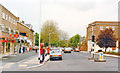
9
Tesco Express, West Dulwich
Mini supermarket on the junction of the A2199 Croxted Road (in front) and Park Hall (on the left).
Image: © David Anstiss
Taken: 2 Oct 2011
0.12 miles
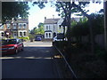
10
Local shops on the No 3 bus route, West Dulwich
There is a wide range of shops and services around this junction of Croxted Road (distant), South Croxted Road (foreground) and Park Hall Road. The No 3 bus runs between Crystal Palace and Whitehall and is frequently seen.
Image: © Robin Stott
Taken: 17 May 2022
0.12 miles