IMAGES TAKEN NEAR TO
Berry Lane, LONDON, SE21 8AR
Introduction
This page details the photographs taken nearby to Berry Lane, SE21 8AR by members of the Geograph project.
The Geograph project started in 2005 with the aim of publishing, organising and preserving representative images for every square kilometre of Great Britain, Ireland and the Isle of Man.

There are currently over 7.5m images from over14,400 individuals and you can help contribute to the project by visiting https://www.geograph.org.uk
Image Map
Images are licensed for reuse under creativecommons.org/licenses/by-sa/2.0
Notes
- Clicking on the map will re-center to the selected point.
- The higher the marker number, the further away the image location is from the centre of the postcode.
Image Listing (61 Images Found)
Images are licensed for reuse under creativecommons.org/licenses/by-sa/2.0
Image
Details
Distance
1
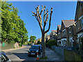
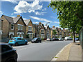
Pollarded street tree, South Croxted Road, Gipsy Hill, London
The Crystal Palace transmitter can be seen to the left.
Image: © Robin Stott
Taken: 14 May 2022
0.05 miles
2
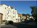
Semi-detached houses, South Croxted Road, West Dulwich
Image: © Robin Stott
Taken: 17 May 2022
0.07 miles
4
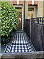
Tiled front garden path, South Croxted Road, Gipsy Hill, London
Image: © Robin Stott
Taken: 14 May 2022
0.07 miles
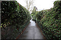
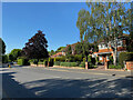
5
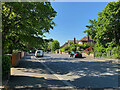
South end of Alleyn Road, West Dulwich, London
Looking north-northwest.
Image: © Robin Stott
Taken: 14 May 2022
0.08 miles
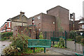
6
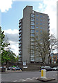
Northwood House, Hamilton Road
This is run by Lambeth Council as a sheltered housing scheme. Built by Lambeth, c1966.
Image: © Stephen Richards
Taken: 12 May 2012
0.09 miles
7
North on Alleyn Road, West Dulwich, London
Image: © Robin Stott
Taken: 14 May 2022
0.10 miles