IMAGES TAKEN NEAR TO
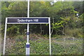
College Road, LONDON, SE21 7ND
Introduction
This page details the photographs taken nearby to College Road, SE21 7ND by members of the Geograph project.
The Geograph project started in 2005 with the aim of publishing, organising and preserving representative images for every square kilometre of Great Britain, Ireland and the Isle of Man.

There are currently over 7.5m images from over14,400 individuals and you can help contribute to the project by visiting https://www.geograph.org.uk
Image Map
Images are licensed for reuse under creativecommons.org/licenses/by-sa/2.0
Notes
- Clicking on the map will re-center to the selected point.
- The higher the marker number, the further away the image location is from the centre of the postcode.
Image Listing (107 Images Found)
Images are licensed for reuse under creativecommons.org/licenses/by-sa/2.0
Image
Details
Distance
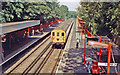
1
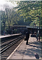
Sydenham Hill station and Penge Tunnel, 1986
View SE on the Up platform, towards Bromley South, Orpington etc.: ex-SE&CR Chatham Main Line to Kent Coast. (Note my briefcase in foreground). Cf. Image and others.
Image: © Ben Brooksbank
Taken: 16 May 1986
0.00 miles
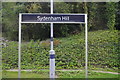
2
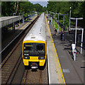
Sydenham Hill Station
A down Southeastern train (2 Class 465 4-car EMUs) is arriving at Platform 2.
Image: © Ian Taylor
Taken: 11 Aug 2019
0.00 miles
3
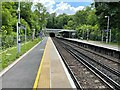
Sydenham Hill railway station, Greater London
Opened in 1863 by the London Chatham & Dover Railway on the line from London Victoria to Bromley South.
View south east towards Penge and Bromley South.
Image: © Nigel Thompson
Taken: 12 Jun 2021
0.00 miles
4
Sydenham Hill railway station, Greater London, 2014
Opened in 1863 by the London Chatham & Dover Railway on the line from London Victoria to Bromley South.
View north west towards West Dulwich and London, during some rebuilding. For a 2021 view in the opposite direction, see Image
Image: © Nigel Thompson
Taken: 6 Mar 2014
0.01 miles
5
Sydenham Hill Station, with local EMU from London 1989
View NW, towards Herne Hill and London Victoria/Blackfriars: ex-SE&CR Chatham main line to Ramsgate/Dover. The local service ran Victoria/Holborn Viaduct (until 5/87, then Blackfriars) - Orpington. The EMU is a Class 416/2. (For 10 years, my commute).
Image: © Ben Brooksbank
Taken: 27 Jul 1989
0.01 miles
6
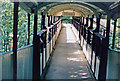
Footbridge at Sydenham Hill station, 1986
View SW, across the tracks: Penge Tunnel and Kent to the left, London to the right. (See Image] for details).
Image: © Ben Brooksbank
Taken: 16 May 1986
0.01 miles
8
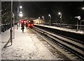
Snowy night at Sydenham Hill station
Image: © Christopher Hilton
Taken: 21 Jan 2013
0.01 miles
10
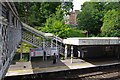
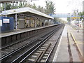
Sydenham Hill Station
Platform 1 from the footbridge, with the southern access path in the background.
The station is in a cutting. Access on both sides is via steps and ramps.
Image: © Ian Taylor
Taken: 11 Aug 2019
0.01 miles