IMAGES TAKEN NEAR TO
Woodhall Drive, LONDON, SE21 7HJ
Introduction
This page details the photographs taken nearby to Woodhall Drive, SE21 7HJ by members of the Geograph project.
The Geograph project started in 2005 with the aim of publishing, organising and preserving representative images for every square kilometre of Great Britain, Ireland and the Isle of Man.

There are currently over 7.5m images from over14,400 individuals and you can help contribute to the project by visiting https://www.geograph.org.uk
Image Map
Images are licensed for reuse under creativecommons.org/licenses/by-sa/2.0
Notes
- Clicking on the map will re-center to the selected point.
- The higher the marker number, the further away the image location is from the centre of the postcode.
Image Listing (116 Images Found)
Images are licensed for reuse under creativecommons.org/licenses/by-sa/2.0
Image
Details
Distance
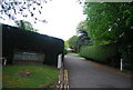
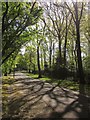
2

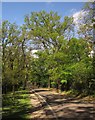
Track in Dulwich Wood (2)
This track leads from Grange Lane towards Upper Sydenham.
It passes through the wood, managed by the Dulwich Estate.
Image: © David Anstiss
Taken: 2 Oct 2011
0.06 miles
4
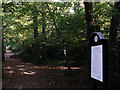
Track in Dulwich Wood (3)
This track leads from Low Cross Wood Lane, Upper Sydenham towards Grange Lane, Dulwich.
It passes through the wood, managed by the Dulwich Estate.
The information panel on the right shows the do's and don'ts.
Image: © David Anstiss
Taken: 2 Oct 2011
0.08 miles
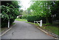
6
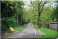
Low Cross Wood Lane, Dulwich
This path leads from College Road to the Upper Sydenham area.
Image: © Stephen McKay
Taken: 26 Mar 2007
0.08 miles
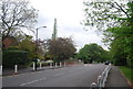
7
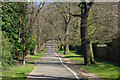
Low Cross Wood Lane
This path leads to Streatham Hill station (behind the photographer).
Image: © N Chadwick
Taken: 9 May 2010
0.09 miles
8
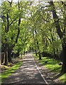
Low Cross Wood Lane
Looking in the other direction, uphill, from the same spot as Image] and a little further up the road than Image The lane climbs along the side of Dulwich Wood, a remnant of the original Great North Wood that gave its name to Norwood.
Image: © Derek Harper
Taken: 9 May 2013
0.09 miles
9
Low Cross Wood Lane
Looking down the stretch of the path that Image] looks up.
Image: © Derek Harper
Taken: 9 May 2013
0.09 miles
10
Low Cross Wood Lane
Taken further up Image], from near the entrance to Dulwich Wood (left), with the lane approaching a right bend.
Image: © Derek Harper
Taken: 9 May 2013
0.10 miles