IMAGES TAKEN NEAR TO
Dulwich Village, LONDON, SE21 7BU
Introduction
This page details the photographs taken nearby to Dulwich Village, SE21 7BU by members of the Geograph project.
The Geograph project started in 2005 with the aim of publishing, organising and preserving representative images for every square kilometre of Great Britain, Ireland and the Isle of Man.

There are currently over 7.5m images from over14,400 individuals and you can help contribute to the project by visiting https://www.geograph.org.uk
Image Map
Images are licensed for reuse under creativecommons.org/licenses/by-sa/2.0
Notes
- Clicking on the map will re-center to the selected point.
- The higher the marker number, the further away the image location is from the centre of the postcode.
Image Listing (179 Images Found)
Images are licensed for reuse under creativecommons.org/licenses/by-sa/2.0
Image
Details
Distance
1
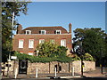
Lydenhurst House, Dulwich
Grade II listed house on the junction of Red Post Hill (on the right) and East Dulwhich Grove (in front).
See http://www.britishlistedbuildings.co.uk/en-471445-lyndenhurst-house-19-camberwell for more details about the building.
Image: © David Anstiss
Taken: 2 Oct 2011
0.06 miles
2
Pond Mead, SE21
Pond Mead, a private housing development in Dulwich Village.
Image: © Malc McDonald
Taken: 17 Oct 2010
0.07 miles
3
Pond House, North Dulwich
Grade II listed house on Village Way.
See http://www.britishlistedbuildings.co.uk/en-471446-pond-house-and-handrails-to-steps-20-cam for more details about the building.
Image: © David Anstiss
Taken: 2 Oct 2011
0.08 miles
4

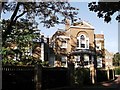
Dulwich Village, parish hall
Well hidden by foliage (at this time of year), at junction Dulwich Village and Gilkes Place, St Barnabas' Parish Hall; the foundation stone is dated 1910. http://www.stbarnabasdulwich.org/November_December_2007.pdf
Image: © Mike Faherty
Taken: 16 Aug 2009
0.08 miles
5
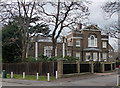
Pond House, Village Way
A grand composition, even if not large. The centre has a canted bay, Venetian window and pediment. The main block is mid C18th, the lower wing early C19th. Grade II listed.
Image: © Stephen Richards
Taken: 6 Apr 2012
0.08 miles
6
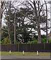
Cedar, Village Way
In the gardens of Pond House Image
Image: © Stephen Richards
Taken: 6 Apr 2012
0.09 miles
7
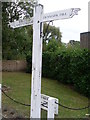
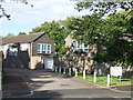
Signpost opposite North Dulwich Station
Situated in Red Post Hill SE21 7BX, this signpost with a hand at each end, shows the direction to Dulwich Village and Dulwich Picture Gallery to the left, and Denmark Hill to the right. The right-hand sign would appear to have been added quite recently. The notice on the ground behind the signpost says: 1-9 Red Post Hill. Deliveries via Pond Mead off Village Way.
Image: © David Hillas
Taken: 4 Oct 2011
0.10 miles
8
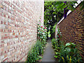
North Dulwich: Hollyhocks
These hollyhocks were seen growing semi-wild in the passage leading to North Dulwich tennis club. The nearer one must be at least 10ft tall, the tallest example I have ever observed.
Image: © Dr Neil Clifton
Taken: 18 Jul 2012
0.10 miles
9
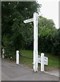
Old Direction Sign - Signpost by Red Post Hill, North Dulwich
No finial - 1 arm; Dulwich cuffed hand by the UC road, in parish of Camberwell and Dulwich (Southwark District), North Dulwich, Red Post Hill, South end.
Surveyed
Milestone Society National ID: SY_TQ3274B
Image: © Milestone Society
Taken: Unknown
0.10 miles
10
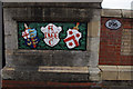
Red Post Hill railway bridge
One of the plaques on the overbridge at North Dulwich station, dated 1866. The shields are for the London Brighton and South Coast Railway (left) and Alleyn's College (now Dulwich College, right).
See Image for a wider view.
The code BTH1 on the bridge number plate indicates that this bridge is on the line from South Bermondsey Junction to Sutton (East) Junction. 4 miles 68 chains (7800m) is the distance from London Bridge.
Image: © Ian Taylor
Taken: 20 Sep 2014
0.11 miles