IMAGES TAKEN NEAR TO
Woodbine Grove, LONDON, SE20 8UY
Introduction
This page details the photographs taken nearby to Woodbine Grove, SE20 8UY by members of the Geograph project.
The Geograph project started in 2005 with the aim of publishing, organising and preserving representative images for every square kilometre of Great Britain, Ireland and the Isle of Man.

There are currently over 7.5m images from over14,400 individuals and you can help contribute to the project by visiting https://www.geograph.org.uk
Image Map
Images are licensed for reuse under creativecommons.org/licenses/by-sa/2.0
Notes
- Clicking on the map will re-center to the selected point.
- The higher the marker number, the further away the image location is from the centre of the postcode.
Image Listing (90 Images Found)
Images are licensed for reuse under creativecommons.org/licenses/by-sa/2.0
Image
Details
Distance
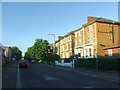
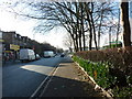
2
Residential Flats
Residential flats at Laurel Grove, Penge.
Image: © Alan Hughes
Taken: 4 Mar 2017
0.09 miles
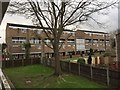
3
Penge Clinic: closed building (detail)
The inscription reads "Penge Station" over an entwined U and C.
Image: © Christopher Hilton
Taken: 23 Dec 2011
0.12 miles
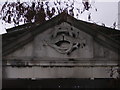
4
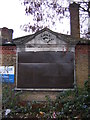
Penge Clinic: closed building
The inscription reads "Penge Station" over an entwined U and C.
Image: © Christopher Hilton
Taken: 23 Dec 2011
0.12 miles
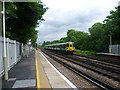
5
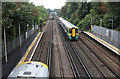
Penge West Station
A southern class 377 electric unit approaches from the south on the fast lines. In the distance is Anerley station
Image: © Martin Addison
Taken: 13 Sep 2013
0.16 miles
6
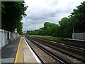
Anerley station
The railway here follows the line of the Croydon Canal which ran for nearly ten miles from Croydon, via Forest Hill, to the Grand Surrey Canal at New Cross. It opened in 1809, and closed in 1836, making it the first canal to be formally abandoned by an Act of Parliament. Much of the alignment was used by the London & Croydon Railway Company (to whom the canal had been sold for £40,250). The station was opened originally as Annerley by the London & Croydon Railway in 1839. It was situated in a largely unpopulated area, but was built as part of an agreement with the local landowner. The line was also used by the London & Brighton Railway from 1841 and the South Eastern Railway from 1842. In the early 1850s, the line was quadrupled and at this time the station was rebuilt. London Overground trains now operate from the station, as well as Southern trains.
Image: © Marathon
Taken: 1 Jun 2012
0.16 miles
7
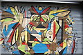
View of shutter art on the front of Golf Rush on Maple Road
Looking north-northwest.
Image: © Robert Lamb
Taken: 18 May 2019
0.17 miles
8
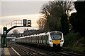
Approaching Penge West
A Thameslink class 700 unit, approaching Penge West, with Anerley station visible in the background.
Image: © Peter Trimming
Taken: 22 Dec 2021
0.18 miles
10
Anerley station
The railway here follows the line of the Croydon Canal which ran for nearly ten miles from Croydon, via Forest Hill, to the Grand Surrey Canal at New Cross. It opened in 1809, and closed in 1836, making it the first canal to be formally abandoned by an Act of Parliament. Much of the alignment was used by the London & Croydon Railway Company (to whom the canal had been sold for £40,250). The station was opened originally as Annerley by the London & Croydon Railway in 1839. It was situated in a largely unpopulated area, but was built as part of an agreement with the local landowner. The line was also used by the London & Brighton Railway from 1841 and the South Eastern Railway from 1842. In the early 1850s, the line was quadrupled and at this time the station was rebuilt. London Overground trains now operate from the station, as well as Southern trains. Here a Southern train races through on the down fast line.
Image: © Marathon
Taken: 1 Jun 2012
0.18 miles