IMAGES TAKEN NEAR TO
Anerley Road, LONDON, SE20 8TJ
Introduction
This page details the photographs taken nearby to Anerley Road, SE20 8TJ by members of the Geograph project.
The Geograph project started in 2005 with the aim of publishing, organising and preserving representative images for every square kilometre of Great Britain, Ireland and the Isle of Man.

There are currently over 7.5m images from over14,400 individuals and you can help contribute to the project by visiting https://www.geograph.org.uk
Image Map
Images are licensed for reuse under creativecommons.org/licenses/by-sa/2.0
Notes
- Clicking on the map will re-center to the selected point.
- The higher the marker number, the further away the image location is from the centre of the postcode.
Image Listing (65 Images Found)
Images are licensed for reuse under creativecommons.org/licenses/by-sa/2.0
Image
Details
Distance
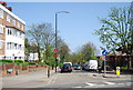
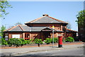
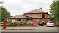
1
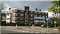
Dover House, Maple Road, Anerley
Image: © Christopher Hilton
Taken: 27 Apr 2016
0.03 miles
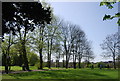
5
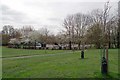
Betts Park Anerley
The kiddies' play area is part of a play school.
Image: © Glyn Baker
Taken: 27 Mar 2019
0.06 miles
9
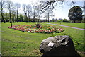
Bromley Millennium Rock, Betts Park
A chunk of rock to celebrate the Millennium!
Image: © N Chadwick
Taken: 9 Apr 2011
0.09 miles
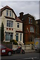
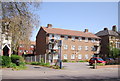
10
Christ Church, Anerley Road, London SE20 8ER
Image: © John Salmon
Taken: 12 Jul 2010
0.10 miles