IMAGES TAKEN NEAR TO
Bolton Close, LONDON, SE20 8TB
Introduction
This page details the photographs taken nearby to Bolton Close, SE20 8TB by members of the Geograph project.
The Geograph project started in 2005 with the aim of publishing, organising and preserving representative images for every square kilometre of Great Britain, Ireland and the Isle of Man.

There are currently over 7.5m images from over14,400 individuals and you can help contribute to the project by visiting https://www.geograph.org.uk
Image Map
Images are licensed for reuse under creativecommons.org/licenses/by-sa/2.0
Notes
- Clicking on the map will re-center to the selected point.
- The higher the marker number, the further away the image location is from the centre of the postcode.
Image Listing (38 Images Found)
Images are licensed for reuse under creativecommons.org/licenses/by-sa/2.0
Image
Details
Distance
1
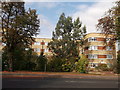
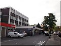
Haysleigh House, South Norwood
Large block of housing on the A213 Croydon Road.
Opposite Image
Image: © David Anstiss
Taken: 16 Oct 2011
0.12 miles
2
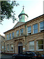
Anerley Town Hall
Anerley Vestry Hall was built in 1878 for conduct of public business of the district, then part of the Borough of Lewisham. It became the Town Hall when Penge Urban District Council was formed in 1900. In 1965, Anerley became part of the new London Borough of Bromley. It now houses Anerley Library, a playgroup, and other amenity groups, and is rented out as a venue for small theatre / drama productions, dancing, and other social functions such as wedding receptions.
Image: © Philip Talmage
Taken: 17 Aug 2005
0.14 miles
3
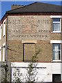
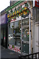
Ghost-sign, Croydon Road, Anerley
"The / Victoria Wine / Co. Ltd. / Wines, Spirits, Beers / & / Mineral Waters"
See Image for context.
Image: © Christopher Hilton
Taken: 21 May 2011
0.14 miles
4
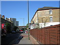
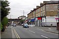
Croydon Road, Anerley, with ghost-sign
This a matter of yards from the point where Croydon Road (Penge) turns into Penge Road (Croydon): the Croydon boundary sign can just be made out on the left side of the road beneath the railway arch.
See Image for a close-up of the ghost-sign.
Image: © Christopher Hilton
Taken: 21 May 2011
0.14 miles
5

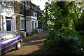
Seymour Terrace, Anerley
Built along the alignment of the former Croydon Canal, whose remaining portion lies in Betts Park over the railings. When the houses were built the canal was already disused. The access road runs along the former towpath.
Image: © Christopher Hilton
Taken: 19 May 2013
0.16 miles
6
Anerley Tesco Express
Small supermarket on the A213 Croydon Road, beside a bookmakers.
Image: © David Anstiss
Taken: 16 Oct 2011
0.16 miles
7
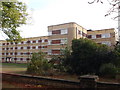
Wheathill House, South Norwood
Large block of housing on the A213 Croydon Road.
Opposite Image
Image: © David Anstiss
Taken: 16 Oct 2011
0.17 miles
8
Seymour Terrace, Anerley
Built along the alignment of the former Croydon Canal, whose remaining portion lies in Betts Park behind the photographer. When the houses were built the canal was already disused. The access road runs along the former towpath.
Image: © Christopher Hilton
Taken: 19 May 2013
0.17 miles
9
Victoria Wine Sign on Croydon Road
At one time "Victoria Wine" Shops were ubiquitous, the sign proves the brand was much older than I ever realised.
Image: © Glyn Baker
Taken: 27 Mar 2019
0.18 miles
10
Taste Good Jamaican cafe, South Norwood
On the Penge Road, Croydon (and thus officially in South Norwood), but a matter of feet from the point where this becomes the Croydon Road, Penge.
Image: © Christopher Hilton
Taken: 19 May 2013
0.18 miles