IMAGES TAKEN NEAR TO
Barfreston Way, LONDON, SE20 8LT
Introduction
This page details the photographs taken nearby to Barfreston Way, SE20 8LT by members of the Geograph project.
The Geograph project started in 2005 with the aim of publishing, organising and preserving representative images for every square kilometre of Great Britain, Ireland and the Isle of Man.

There are currently over 7.5m images from over14,400 individuals and you can help contribute to the project by visiting https://www.geograph.org.uk
Image Map
Images are licensed for reuse under creativecommons.org/licenses/by-sa/2.0
Notes
- Clicking on the map will re-center to the selected point.
- The higher the marker number, the further away the image location is from the centre of the postcode.
Image Listing (78 Images Found)
Images are licensed for reuse under creativecommons.org/licenses/by-sa/2.0
Image
Details
Distance
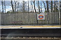
1
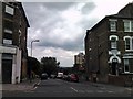
Panorama from Anerley Hill #2
Looking north-northeast into Minden Road.
Image: © Robert Lamb
Taken: 14 Jul 2011
0.09 miles
7
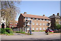
Seymour Villas at the junction of Anerley Road
Image: © David Howard
Taken: 7 Oct 2012
0.13 miles
8
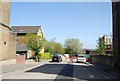
Anerley House, Anerley Station Road
The firm Victorian full stop brooks no argument.
Image: © Christopher Hilton
Taken: 23 Dec 2011
0.13 miles
10
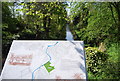
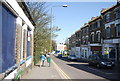
Information board, Croydon Canal, Betts Park
The Croydon Canal ran 9 miles from Croydon, via Forest Hill, to the Grand Surrey Canal at New Cross. It opened in 1809, and closed in 1836, making it the first canal to be formally abandoned by an Act of Parliament.
Image: © N Chadwick
Taken: 9 Apr 2011
0.13 miles