IMAGES TAKEN NEAR TO
Thornsett Road, LONDON, SE20 7XE
Introduction
This page details the photographs taken nearby to Thornsett Road, SE20 7XE by members of the Geograph project.
The Geograph project started in 2005 with the aim of publishing, organising and preserving representative images for every square kilometre of Great Britain, Ireland and the Isle of Man.

There are currently over 7.5m images from over14,400 individuals and you can help contribute to the project by visiting https://www.geograph.org.uk
Image Map
Images are licensed for reuse under creativecommons.org/licenses/by-sa/2.0
Notes
- Clicking on the map will re-center to the selected point.
- The higher the marker number, the further away the image location is from the centre of the postcode.
Image Listing (46 Images Found)
Images are licensed for reuse under creativecommons.org/licenses/by-sa/2.0
Image
Details
Distance
1
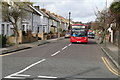
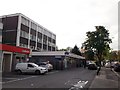
Southeast London: Wheathill Road
Looking north west from a four-way junction where it meets Marlow Road, Warwick Road, and Cambridge Road. The bus is on Route 356, destined for Shirley.
Image: © Dr Neil Clifton
Taken: 11 Mar 2011
0.06 miles
2
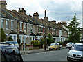
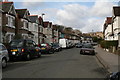
Terrace houses, Stembridge Road
The housing in this area varies substantially in age from road to road. This is one of the older roads.
Image: © Robin Webster
Taken: 11 Jun 2011
0.07 miles
3
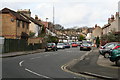
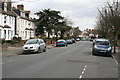
Southeast London: Cambridge Road
Looking north west from its junction with Marlow Road, Wheathill Road, and Warwick Road
Image: © Dr Neil Clifton
Taken: 11 Mar 2011
0.08 miles
4
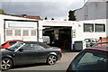
Southeast London: Alton Motors, Cambridge Road
Image: © Dr Neil Clifton
Taken: 11 Mar 2011
0.08 miles
5
Southeast London: Cambridge Road
Looking northwest from opposite No 80.
Image: © Dr Neil Clifton
Taken: 11 Mar 2011
0.09 miles
6
Southeast London: Marlow Road
Looking north east from its junction with Warwick Road
Image: © Dr Neil Clifton
Taken: 11 Mar 2011
0.09 miles
7
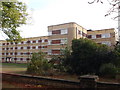
Wheathill House, South Norwood
Large block of housing on the A213 Croydon Road.
Opposite Image
Image: © David Anstiss
Taken: 16 Oct 2011
0.10 miles
8
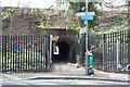
Southeast London: Passage under the railway
This unsavoury but useful subway under the railway gives access from Cambridge Road to the Love Lane footpath, and thence to Harrington Road tram stop, with frequent cars to the centre of Croydon.
Image: © Dr Neil Clifton
Taken: 11 Mar 2011
0.12 miles
9
Anerley Tesco Express
Small supermarket on the A213 Croydon Road, beside a bookmakers.
Image: © David Anstiss
Taken: 16 Oct 2011
0.13 miles
10
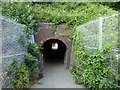
Foot tunnel under railway
From Hambrook Road and others this side, to Cambridge Road on the far side.
Image: © Robin Webster
Taken: 11 Jun 2011
0.14 miles