IMAGES TAKEN NEAR TO
Marlow Road, LONDON, SE20 7UY
Introduction
This page details the photographs taken nearby to Marlow Road, SE20 7UY by members of the Geograph project.
The Geograph project started in 2005 with the aim of publishing, organising and preserving representative images for every square kilometre of Great Britain, Ireland and the Isle of Man.

There are currently over 7.5m images from over14,400 individuals and you can help contribute to the project by visiting https://www.geograph.org.uk
Image Map
Images are licensed for reuse under creativecommons.org/licenses/by-sa/2.0
Notes
- Clicking on the map will re-center to the selected point.
- The higher the marker number, the further away the image location is from the centre of the postcode.
Image Listing (66 Images Found)
Images are licensed for reuse under creativecommons.org/licenses/by-sa/2.0
Image
Details
Distance
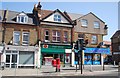
3
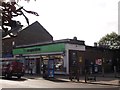
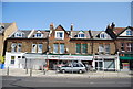
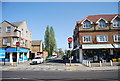
Co-operative Supermarket, Anerley
Small supermarket on the junction of Elmer's End Road (in front) and Bourdon Road (on the right).
Image: © David Anstiss
Taken: 16 Oct 2011
0.06 miles
7
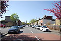
Southeast London:Felmingham Road
Looking north west from its junction with Witham Road. A primary school is on the left.
Image: © Dr Neil Clifton
Taken: 11 Mar 2011
0.07 miles
9
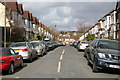
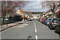
Southeast London: Piquet Road
Looking north west from its junction with Witham Road
Image: © Dr Neil Clifton
Taken: 11 Mar 2011
0.08 miles