IMAGES TAKEN NEAR TO
Parish Lane, LONDON, SE20 7LH
Introduction
This page details the photographs taken nearby to Parish Lane, SE20 7LH by members of the Geograph project.
The Geograph project started in 2005 with the aim of publishing, organising and preserving representative images for every square kilometre of Great Britain, Ireland and the Isle of Man.

There are currently over 7.5m images from over14,400 individuals and you can help contribute to the project by visiting https://www.geograph.org.uk
Image Map
Images are licensed for reuse under creativecommons.org/licenses/by-sa/2.0
Notes
- Clicking on the map will re-center to the selected point.
- The higher the marker number, the further away the image location is from the centre of the postcode.
Image Listing (246 Images Found)
Images are licensed for reuse under creativecommons.org/licenses/by-sa/2.0
Image
Details
Distance
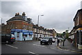
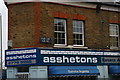
2
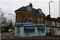
Estate agent at the corner of Parish Lane
See Image for a closer view of the street name-sign above the fascia.
Image: © Christopher Hilton
Taken: 24 Apr 2016
0.04 miles
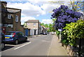
6
Estate agent at the corner of Parish Lane
See Image for a view of the building as a whole.
Image: © Christopher Hilton
Taken: 24 Apr 2016
0.05 miles
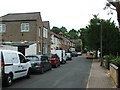
7
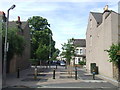
Hardings Lane, Penge
The northern end of Hardings lane has been closed to motor vehicles, to prevent traffic from "rat-running" through residential streets. There is still a way through for cyclists.
Image: © Malc McDonald
Taken: 25 May 2011
0.05 miles