IMAGES TAKEN NEAR TO
High Street, LONDON, SE20 7HB
Introduction
This page details the photographs taken nearby to High Street, SE20 7HB by members of the Geograph project.
The Geograph project started in 2005 with the aim of publishing, organising and preserving representative images for every square kilometre of Great Britain, Ireland and the Isle of Man.

There are currently over 7.5m images from over14,400 individuals and you can help contribute to the project by visiting https://www.geograph.org.uk
Image Map
Images are licensed for reuse under creativecommons.org/licenses/by-sa/2.0
Notes
- Clicking on the map will re-center to the selected point.
- The higher the marker number, the further away the image location is from the centre of the postcode.
Image Listing (312 Images Found)
Images are licensed for reuse under creativecommons.org/licenses/by-sa/2.0
Image
Details
Distance
1

64 High Street, Penge
Recorded as a former World War One drill hall, but if so, an unusual one. Perhaps there was a hall behind?
Image: © Christine Johnstone
Taken: 22 Apr 2015
0.01 miles
2
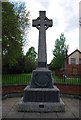
Penge Cenotaph
The view on the High Street opposite the Church of St John the Evangelist.
Image: © Gordon Griffiths
Taken: 15 Nov 2015
0.01 miles
3
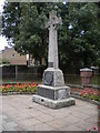
Penge War Memorial, Penge High Street SE20
Image: © Robin Sones
Taken: 30 Aug 2011
0.02 miles
4
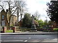
War memorial, Penge High Street
The central monument records fallen combatants from the First World War. The plaques on the left [east] side of the fence record fallen combatants in the Second World War. The plaques on the right [west] side of the fence record civilians who died in the Second World War.
Image: © Christine Johnstone
Taken: 22 Apr 2015
0.02 miles
5
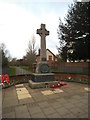
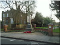
View of the war memorial by the entrance to Penge Recreation Ground from Penge High Street
Looking south-southwest.
Image: © Robert Lamb
Taken: 18 May 2019
0.02 miles
6
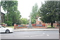
Penge War Memorial
On the south side of the High Street, Penge War Memorial is attractively sited at the entrance to a small park. When the photograph was taken, light-controlled roadworks were taking place here enabling a clear view of the memorial without the risk of being run over.
Image: © Marathon
Taken: 24 Feb 2011
0.02 miles
7

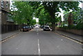
Boarded up house, off Penge High Street
At the entrance to the recreation ground. Probably once the park-keeper's.
Image: © Christine Johnstone
Taken: 22 Apr 2015
0.02 miles
8
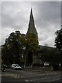
St John's Church, Penge High Street SE20
At the junction with St John's Road
Image: © Robin Sones
Taken: 30 Aug 2011
0.03 miles