IMAGES TAKEN NEAR TO
Penge Lane, LONDON, SE20 7DU
Introduction
This page details the photographs taken nearby to Penge Lane, SE20 7DU by members of the Geograph project.
The Geograph project started in 2005 with the aim of publishing, organising and preserving representative images for every square kilometre of Great Britain, Ireland and the Isle of Man.

There are currently over 7.5m images from over14,400 individuals and you can help contribute to the project by visiting https://www.geograph.org.uk
Image Map
Images are licensed for reuse under creativecommons.org/licenses/by-sa/2.0
Notes
- Clicking on the map will re-center to the selected point.
- The higher the marker number, the further away the image location is from the centre of the postcode.
Image Listing (285 Images Found)
Images are licensed for reuse under creativecommons.org/licenses/by-sa/2.0
Image
Details
Distance
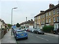
3
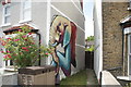
View of elephant street art on the side of a house on Southey Street
Looking north-northwest.
Image: © Robert Lamb
Taken: 18 May 2019
0.03 miles

5
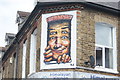
View of Sr. X street art above Himalayan Kitchen Nepalese and Indian Takeaway on Penge Lane
Looking north-northeast.
Image: © Robert Lamb
Taken: 18 May 2019
0.03 miles
7
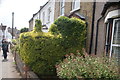
View of a hedge shaped like a steam train on Southey Street
Looking south-southwest.
Image: © Robert Lamb
Taken: 18 May 2019
0.04 miles
8
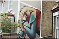
View of elephant street art on the side of a house on Southey Street
Looking south-southwest.
Image: © Robert Lamb
Taken: 18 May 2019
0.04 miles
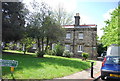
10
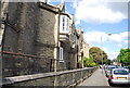
The Royal Waterman's and Lighterman's Asylum
Image: © N Chadwick
Taken: 12 May 2012
0.04 miles