IMAGES TAKEN NEAR TO
Montague Mews, LONDON, SE20 7BA
Introduction
This page details the photographs taken nearby to Montague Mews, SE20 7BA by members of the Geograph project.
The Geograph project started in 2005 with the aim of publishing, organising and preserving representative images for every square kilometre of Great Britain, Ireland and the Isle of Man.

There are currently over 7.5m images from over14,400 individuals and you can help contribute to the project by visiting https://www.geograph.org.uk
Image Map
Images are licensed for reuse under creativecommons.org/licenses/by-sa/2.0
Notes
- Clicking on the map will re-center to the selected point.
- The higher the marker number, the further away the image location is from the centre of the postcode.
Image Listing (231 Images Found)
Images are licensed for reuse under creativecommons.org/licenses/by-sa/2.0
Image
Details
Distance
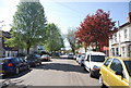
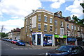
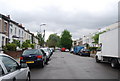
1
Kingswood Rd, Penge
Route of the Capital Ring and Green Chain Walk.
Image: © N Chadwick
Taken: 9 May 2010
0.02 miles

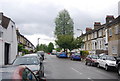
4
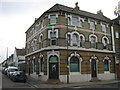
Safe Haven, Penge
Large refuge centre on the corner of Penge High Street and Crampton Road.
Image: © David Anstiss
Taken: 10 Jul 2011
0.04 miles
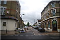
5
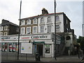
Costcutter Supermarket, Penge
On the corner of Penge High Street (in front) and Oakfield Road (on the right).
Image: © David Anstiss
Taken: 10 Jul 2011
0.04 miles
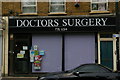
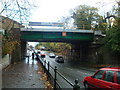
8
Kingswood Rd, Penge
The route of the Capital Ring and Green Chain Walk.
Image: © N Chadwick
Taken: 9 May 2010
0.05 miles