IMAGES TAKEN NEAR TO
Chevening Road, LONDON, SE19 3TD
Introduction
This page details the photographs taken nearby to Chevening Road, SE19 3TD by members of the Geograph project.
The Geograph project started in 2005 with the aim of publishing, organising and preserving representative images for every square kilometre of Great Britain, Ireland and the Isle of Man.

There are currently over 7.5m images from over14,400 individuals and you can help contribute to the project by visiting https://www.geograph.org.uk
Image Map
Images are licensed for reuse under creativecommons.org/licenses/by-sa/2.0
Notes
- Clicking on the map will re-center to the selected point.
- The higher the marker number, the further away the image location is from the centre of the postcode.
Image Listing (105 Images Found)
Images are licensed for reuse under creativecommons.org/licenses/by-sa/2.0
Image
Details
Distance
3
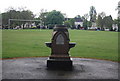
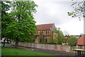
Drinking Fountain, Upper Norwood Recreation Ground
Image: © N Chadwick
Taken: 8 May 2010
0.03 miles
4
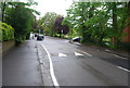
Orleans Road, SE19
Orleans Road here runs along the floor of a dip that marks the line of the River Effra, one of London's "lost" (largely-culverted) rivers, which rises here and flows to the Thames at Vauxhall. From the manhole cover close to the camera comes a constant sound of running water, presumably from the culverted stream below.
Image: © Christopher Hilton
Taken: 21 Apr 2016
0.05 miles
5
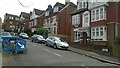
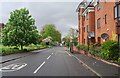
Victorian villas on Vermont Road, SE19
The heavy porches with their balconies above characterise the Victorian developments on this and adjacent roads.
Image: © Christopher Hilton
Taken: 21 Apr 2016
0.05 miles
6
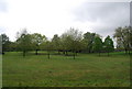
Trees, Upper Norwood Recreation Ground
A 19 acre ground, since 1890
Image: © N Chadwick
Taken: 8 May 2010
0.07 miles
10

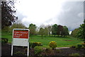
Upper Norwood Recreation Ground
Upper Norwood Recreation Ground was acquired by the Council in 1890 from the Ecclesiastical Commissioners for about £6,500. It was opened by the Mayor who had come directly from opening the new Wandle Park. It was said at the time that one of the best things about it was the views of the Crystal Palace. The recreation ground contains one of the headwaters of the River Effra which now runs underground, but it was still visible at the start of the 20th century. There are fine views towards Battersea Power Station and up to the Crystal Palace ridge and TV mast. The Capital Ring crosses the recreation ground.
Image: © Marathon
Taken: 21 Oct 2011
0.08 miles