IMAGES TAKEN NEAR TO
Harold Road, LONDON, SE19 3SP
Introduction
This page details the photographs taken nearby to Harold Road, SE19 3SP by members of the Geograph project.
The Geograph project started in 2005 with the aim of publishing, organising and preserving representative images for every square kilometre of Great Britain, Ireland and the Isle of Man.

There are currently over 7.5m images from over14,400 individuals and you can help contribute to the project by visiting https://www.geograph.org.uk
Image Map
Images are licensed for reuse under creativecommons.org/licenses/by-sa/2.0
Notes
- Clicking on the map will re-center to the selected point.
- The higher the marker number, the further away the image location is from the centre of the postcode.
Image Listing (189 Images Found)
Images are licensed for reuse under creativecommons.org/licenses/by-sa/2.0
Image
Details
Distance
1
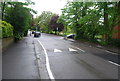
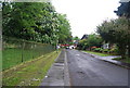
Victorian villas on Vermont Road, SE19
The heavy porches with their balconies above characterise the Victorian developments on this and adjacent roads.
Image: © Christopher Hilton
Taken: 21 Apr 2016
0.05 miles
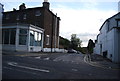
2
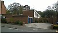
Rochdale, Harold Road, SE19
Rochdale comprises the low-rise blocks closest to the camera plus the blocks of flats in the background, which lie on Central Hill.
Image: © Christopher Hilton
Taken: 21 Apr 2016
0.05 miles
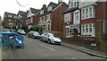
7
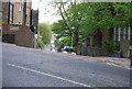
Upper Norwood: Bedwardine Road
From South Vale
Image: © Dr Neil Clifton
Taken: 26 Jul 2012
0.09 miles
8
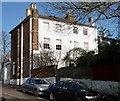
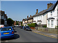
57 and 59 Central Hill
They look possibly early C19th, but since they are not listed, perhaps after 1840. There is a cluster of houses of a similar vintage in the area. This pair present their back to Central Hill, which can just be seen on the far left.
Image: © Stephen Richards
Taken: Unknown
0.09 miles
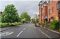
9
Orleans Road, SE19
Orleans Road here runs along the floor of a dip that marks the line of the River Effra, one of London's "lost" (largely-culverted) rivers, which rises here and flows to the Thames at Vauxhall. From the manhole cover close to the camera comes a constant sound of running water, presumably from the culverted stream below.
Image: © Christopher Hilton
Taken: 21 Apr 2016
0.09 miles