1
Upper Norwood: "ghost-signs" on Westow Street
Image: © Christopher Hilton
Taken: 19 Feb 2008
0.01 miles
2
Upper Norwood: "ghost-sign" on Westow Street
"Drapery" is about all I can make out of this. However, a "blue plaque" sticker placed in 2017 in the window of the restaurant that then occupied the premises provided more detail, noting that from 1905 to 1979 this was the site of James Jackson's draper's shop. (See
Image).
Image: © Christopher Hilton
Taken: 19 Feb 2008
0.01 miles
3
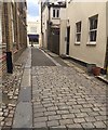
Childs Lane, Crystal Palace ?triangle?, south London
One of the many lanes and alleys that lead into the residential heart of the 'triangle'. The view is towards Westow Street. The wide flat stones may have been of a size to take the weight of wheeled traffic.
Image: © Robin Stott
Taken: 28 May 2019
0.01 miles
4
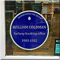
Sign, 21 Westow Street
Norwood Society had the natty idea, which I haven't seen anywhere else, of placing blue signs in shops in the Crystal Palace 'Triangle' showing significant historic occupants. There are more than a hundred.
This one, in the window of what is now a restaurant, Mediterranea, reads, "William Coldman / Railway booking office / 1903-1932".
Image: © Stephen Richards
Taken: 8 Aug 2018
0.01 miles
5
Carberry Road, Crystal Palace
Image: © Chris Whippet
Taken: 9 Aug 2015
0.01 miles
6
Crystal Palace Rainbow Nursery, Carberry Road, Upper Norwood
Carberry Road is a quiet cul-de-sac in the villagey heart of the Crystal Palace 'triangle'. The ball-topped railings are believed to be locally made; pleasing examples may be come upon
Image
Image: © Robin Stott
Taken: 2 Aug 2020
0.01 miles
7
West on Childs Lane, Upper Norwood, south London
Childs Lane is one of several narrow ways into the largely residential heart of the Crystal Palace 'triangle'. The view is to a shoe shop in Westow Street.
Image: © Robin Stott
Taken: 5 Oct 2019
0.02 miles
8
Carberry Road off Westow Street, Crystal Palace ?triangle?, south London
Looking across Westow Street from the corner of Haynes Lane.
Image: © Robin Stott
Taken: 28 May 2019
0.02 miles
9
Norwood Society "blue plaque", Westow Street SE19
In June 2017 many shops in the Crystal Palace triangle acquired stickers in their window like this: mock "blue plaques" from the Norwood Society describing a business that had previously traded there. In this case, a ghost-sign on the side of the building also speaks of its past as a draper's shop (see
Image).
Image: © Christopher Hilton
Taken: 10 Jun 2017
0.02 miles
10
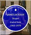
Sign, 17 Westow Street
Norwood Society had the natty idea, which I haven't seen anywhere else, of placing blue signs in shops in the Crystal Palace 'Triangle' showing significant historic occupants. There are more than a hundred.
This one, in the window of what is now a Nepalese restaurant, Gurkha Cottage, records an impressively long presence: "James Jackson / Draper traded here / 1905-1979".
Image: © Stephen Richards
Taken: 8 Aug 2018
0.02 miles


