IMAGES TAKEN NEAR TO
Hermitage Gardens, LONDON, SE19 3QP
Introduction
This page details the photographs taken nearby to Hermitage Gardens, SE19 3QP by members of the Geograph project.
The Geograph project started in 2005 with the aim of publishing, organising and preserving representative images for every square kilometre of Great Britain, Ireland and the Isle of Man.

There are currently over 7.5m images from over14,400 individuals and you can help contribute to the project by visiting https://www.geograph.org.uk
Image Map
Images are licensed for reuse under creativecommons.org/licenses/by-sa/2.0
Notes
- Clicking on the map will re-center to the selected point.
- The higher the marker number, the further away the image location is from the centre of the postcode.
Image Listing (55 Images Found)
Images are licensed for reuse under creativecommons.org/licenses/by-sa/2.0
Image
Details
Distance
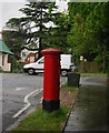
4
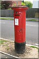
Edward VIII postbox, Hermitage Road, SE19
The location of this postbox is shown in Image
Image: © Mike Quinn
Taken: 14 May 2008
0.05 miles
6
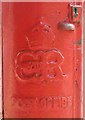
Edward VIII postbox, Hermitage Road, SE19 - royal cipher
See Image
Image: © Mike Quinn
Taken: 14 May 2008
0.05 miles
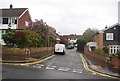
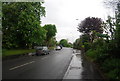
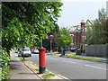
7
Traffic calming, Hermitage Rd
The route of the Capital Ring.
Image: © N Chadwick
Taken: 8 May 2010
0.06 miles
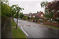
9
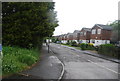
(Part of) Hermitage Road, SE19
Shows the location of Image
Image: © Mike Quinn
Taken: 14 May 2008
0.06 miles