IMAGES TAKEN NEAR TO
Hermitage Road, LONDON, SE19 3QN
Introduction
This page details the photographs taken nearby to Hermitage Road, SE19 3QN by members of the Geograph project.
The Geograph project started in 2005 with the aim of publishing, organising and preserving representative images for every square kilometre of Great Britain, Ireland and the Isle of Man.

There are currently over 7.5m images from over14,400 individuals and you can help contribute to the project by visiting https://www.geograph.org.uk
Image Map
Images are licensed for reuse under creativecommons.org/licenses/by-sa/2.0
Notes
- Clicking on the map will re-center to the selected point.
- The higher the marker number, the further away the image location is from the centre of the postcode.
Image Listing (87 Images Found)
Images are licensed for reuse under creativecommons.org/licenses/by-sa/2.0
Image
Details
Distance
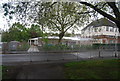
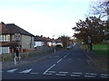
1
Hermitage Road, Norwood
Looking up Hermitage Road towards Central Hill; the street to the left is also considered to be part of Hermitage Road. It is mid-afternoon and a group of schoolboys can be seen ambling home.
Image: © Stephen McKay
Taken: 6 Sep 2018
0.03 miles
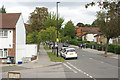
2
Rockmount Road, SE19
The dip in the road at the bend represents the course of the River Effra, one of London's "lost" (largely-culverted) rivers, which rises here and flows to the Thames at Vauxhall.
Image: © Christopher Hilton
Taken: 21 Apr 2016
0.04 miles
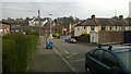
3
Hermitage Road, Upper Norwood
This image was taken in late afternoon sunshine in the month of November.
Image: © Malc McDonald
Taken: 18 Nov 2012
0.06 miles
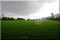
5
Upper Norwood Recreation Ground
The Crystal Palace transmitting station is on the horizon.
Image: © Robin Drayton
Taken: 21 Dec 2015
0.10 miles
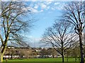
6
A line of trees, Upper Norwood Recreation Ground
Image: © N Chadwick
Taken: 8 May 2010
0.12 miles
7

Chevening Road and Upper Norwood Recreation Ground
Image: © Christopher Hilton
Taken: 7 Oct 2007
0.12 miles
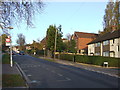
8
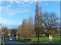
Hermitage Road, Upper Norwood
By the junction with Eversley Road with Upper Norwood Recreation Ground to the right.
Image: © Robin Drayton
Taken: 21 Dec 2015
0.13 miles
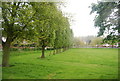
9
Upper Norwood Recreation Ground
A 19 acre recreation ground, since bought by the council in 1890.
Image: © N Chadwick
Taken: 8 May 2010
0.13 miles