IMAGES TAKEN NEAR TO
College Green, LONDON, SE19 3PR
Introduction
This page details the photographs taken nearby to College Green, SE19 3PR by members of the Geograph project.
The Geograph project started in 2005 with the aim of publishing, organising and preserving representative images for every square kilometre of Great Britain, Ireland and the Isle of Man.

There are currently over 7.5m images from over14,400 individuals and you can help contribute to the project by visiting https://www.geograph.org.uk
Image Map
Images are licensed for reuse under creativecommons.org/licenses/by-sa/2.0
Notes
- Clicking on the map will re-center to the selected point.
- The higher the marker number, the further away the image location is from the centre of the postcode.
Image Listing (175 Images Found)
Images are licensed for reuse under creativecommons.org/licenses/by-sa/2.0
Image
Details
Distance
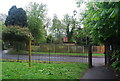
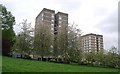
1
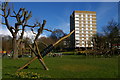
Playground and flats, College Green SE19
Image: © Christopher Hilton
Taken: 28 Mar 2016
0.01 miles
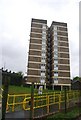
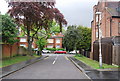
10
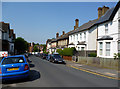
Upper Norwood: Bedwardine Road
From South Vale
Image: © Dr Neil Clifton
Taken: 26 Jul 2012
0.08 miles