IMAGES TAKEN NEAR TO
Queen Mary Road, LONDON, SE19 3NW
Introduction
This page details the photographs taken nearby to Queen Mary Road, SE19 3NW by members of the Geograph project.
The Geograph project started in 2005 with the aim of publishing, organising and preserving representative images for every square kilometre of Great Britain, Ireland and the Isle of Man.

There are currently over 7.5m images from over14,400 individuals and you can help contribute to the project by visiting https://www.geograph.org.uk
Image Map
Images are licensed for reuse under creativecommons.org/licenses/by-sa/2.0
Notes
- Clicking on the map will re-center to the selected point.
- The higher the marker number, the further away the image location is from the centre of the postcode.
Image Listing (75 Images Found)
Images are licensed for reuse under creativecommons.org/licenses/by-sa/2.0
Image
Details
Distance
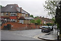
5
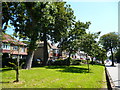
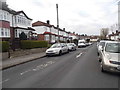
Upper Norwood: 'Semis' on Beulah Hill
Image: © Dr Neil Clifton
Taken: 24 Jul 2012
0.11 miles
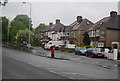
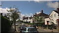
6
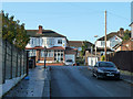
Woodend, SE19
Climbing to Bradley Road, but actually for vehicles one-way down the hill.
Image: © Robin Webster
Taken: 19 Nov 2011
0.11 miles
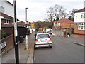
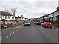
8
Houses, Upper Norwood
On Bradley Road.
Image: © Robin Webster
Taken: 19 Nov 2011
0.12 miles
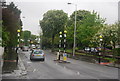
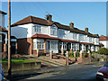
10
Moore Road, West Norwood
Like Image, this looks up the suburban road from close to the junction with Crown Dale, the A214, but concentrates more on the houses on the west side of the road.
Image: © Derek Harper
Taken: 9 May 2013
0.12 miles