IMAGES TAKEN NEAR TO
Our Ladys Close, LONDON, SE19 3FA
Introduction
This page details the photographs taken nearby to Our Ladys Close, SE19 3FA by members of the Geograph project.
The Geograph project started in 2005 with the aim of publishing, organising and preserving representative images for every square kilometre of Great Britain, Ireland and the Isle of Man.

There are currently over 7.5m images from over14,400 individuals and you can help contribute to the project by visiting https://www.geograph.org.uk
Image Map
Images are licensed for reuse under creativecommons.org/licenses/by-sa/2.0
Notes
- Clicking on the map will re-center to the selected point.
- The higher the marker number, the further away the image location is from the centre of the postcode.
Image Listing (90 Images Found)
Images are licensed for reuse under creativecommons.org/licenses/by-sa/2.0
Image
Details
Distance
6
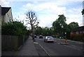
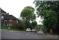
Hermitage Road, Upper Norwood
This image was taken in late afternoon sunshine in the month of November.
Image: © Malc McDonald
Taken: 18 Nov 2012
0.07 miles
7
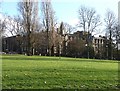
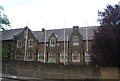
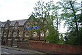
Norwood Park (4)
Behind the trees looms the Virgo Fidelis Convent School (1857-, by William Wardell). A council sign has the following details of the park:
"The name of the park is a reminder that this high ground was once completely cloaked with trees and was part of the ‘Great North Wood’ which covered over 1,400 acres of the old county of Surrey. Over time the North Wood was gradually lost to housing, fields and roads, and by the end of the C18th it had gone completely in Lambeth. Norwood Park was officially opened to the public in 1911, and contains a splendid mix of trees, a wildlife area, playground, games court and padding pool.”
Image: © Stephen Richards
Taken: Unknown
0.07 miles
10
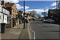
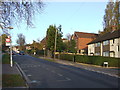
Bus stop on Central Hill, Upper Norwood, London
The stop for Salter's Hill, which borders Norwood Park. It is a request stop on routes 417, 432, N2 and N137. Steep Central Hill leads up to the Crystal Palace ridge.
Image: © Robin Stott
Taken: 6 Mar 2020
0.08 miles