IMAGES TAKEN NEAR TO
Templeton Close, LONDON, SE19 3DD
Introduction
This page details the photographs taken nearby to Templeton Close, SE19 3DD by members of the Geograph project.
The Geograph project started in 2005 with the aim of publishing, organising and preserving representative images for every square kilometre of Great Britain, Ireland and the Isle of Man.

There are currently over 7.5m images from over14,400 individuals and you can help contribute to the project by visiting https://www.geograph.org.uk
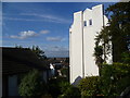
Image Map
Images are licensed for reuse under creativecommons.org/licenses/by-sa/2.0
Notes
- Clicking on the map will re-center to the selected point.
- The higher the marker number, the further away the image location is from the centre of the postcode.
Image Listing (192 Images Found)
Images are licensed for reuse under creativecommons.org/licenses/by-sa/2.0
Image
Details
Distance
1
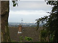
Looking along the curve of the Norwood Heights: north-west from Grange Road
Image: © Christopher Hilton
Taken: 16 Sep 2011
0.03 miles
2
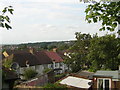
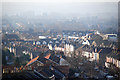
View from Beauchamp Road
There are fine views from the Upper Norwood Ridge around Beulah Hill and Grange Road. This is the view across South London from Beauchamp Road near the junction with Grange Road. The house on the right must have stupendous views.
Image: © Marathon
Taken: 21 Oct 2011
0.06 miles
3
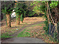
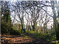
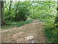
Walk through wooded area - between Grange Road and Beaulieu Heights
A pleasant wooded area, offering a walk between Grange Road up towards Beaulah Hill / Spa Hill. Sometimes referred to as The Lawns
Image: © Chris L L
Taken: 28 Dec 2008
0.06 miles
4
Grange Road: view southwest to Sutton
Image: © Christopher Hilton
Taken: 20 Sep 2011
0.07 miles
5
A path through The Lawns, Upper Norwood
The Lawns is predominately an open space but it is bounded on its north-eastern edge by a strip of attractive woodland.
The following shared description is provided by N Chadwick.
Image: © Robin Drayton
Taken: 20 Jan 2019
0.08 miles
6
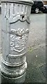
Croydon Borough arms on decommissioned lamp-post, Kingslyn Crescent, SE19
During 2013 the London Borough of Croydon decommissioned many of these old lamp-posts bearing the borough arms and replaced them with newer, brighter and more energy-efficient models. This, like many, was cut off at about four feet up and sealed up with insulating tape; the photo was taken whilst it was an amputated stump in this manner.
To see this in context go to Image
Image: © Christopher Hilton
Taken: 21 Oct 2013
0.08 miles
7
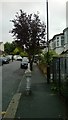
Kingslyn Crescent, SE19
The decommissioned lamp-post in the foreground can be seen in detail at Image
Image: © Christopher Hilton
Taken: 21 Oct 2013
0.08 miles
8
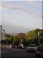
Grange Road, Upper Norwood: view south
In the distance, the towers of Croydon town centre and beyond them the green space of Roundshaw Park.
Image: © Christopher Hilton
Taken: 13 Sep 2011
0.08 miles
9
view from Grange Road over parts of SE London
Haze / air pollution is quite apparent even at 9/ 10 o'clock on a bright and breezy day
Image: © Chris L L
Taken: 29 Dec 2008
0.08 miles
10
Woodland walk at The Lawns
The name The Lawns does not give much indication of the history of this site but it was actually the location of the Beulah Spa. The properties of the mineral spring which was here had been known for many years and during a court case it was proved that the water contained more salts than the water at Cheltenham Spa. It could not rely though on income from people coming to take the waters so in 1831 it was opened as a place for entertainment. The gardens were laid out by Decimus Burton. Fine views were (and still are) to be had, and the entertainments included a maze, a circus and an orchestra. The water was bottled as Beulah Saline Water and sold for two shillings a gallon. The Spa’s popularity started to decline at the time that the Crystal Palace opened in 1854 and in 1858 the estate was put up for auction and much was subsequently developed. In 1939 ‘The Lawns Estate’ was conveyed to Croydon Corporation. More than half of the park is woodland as can be seen here.
Image: © Marathon
Taken: 21 Oct 2011
0.09 miles